Archives for category: made maps

Alice Street map

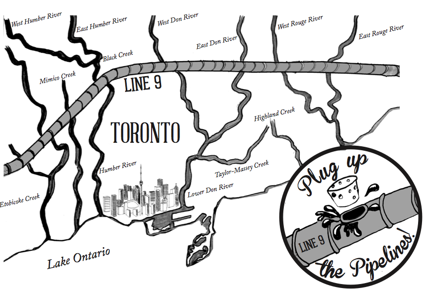
There are, perhaps, no streets more different in Guelph than Alice Street and Woodlawn Road.

On Alice, a jumble of brick houses have been built up to the edge of the street. Before the rise of big box, Alice Street was a hybrid residential-commercial thoroughfare and the heart of the Italian community with general stores and shoe shops in its reconfigured houses. Many of these shops have since turned back into houses, but have been forever distinguished by their past modifications. The effect is an incredibly unique streetscape, like I’ve never seen before, a street of houses with unique DIY renovations, where neighbours hang out on front porches, cars drive slow – the feeling of village and the height of urbanity.

Those aforementioned big box stores – well, they eventually ended up on Woodlawn Road, a street at the northern edge of the city and home to Guelph’s Wal-Mart, Home Depot and various other gigantic corporate retailers.

Woodlawn is a street no one loves but everyone must visit eventually. When I first moved to Guelph, I ended up there countless times, dreading my visits but in need of inexpensive home items only sold there. Woodlawn is the typical non-place at the edge of every city in North America – characterized by the bright signs of fast food restaurants and the complete rejection of walking as a mode of transportation. There are no public gathering spaces on Woodlawn.

It’s easy to love Alice Street. It’s not so easy to love Woodlawn.

So I mapped both, trying to extend my love of place in general to a place that’s hard to love.

And of course, Woodlawn isn’t a non-place, it’s a real place. By choosing to create an illustrated map of it, I’m trying to find its essence beneath the concrete and beyond the international corporate crust that has founds its way there. By mapping Woodlawn, I discovered unique businesses, residential hold-outs, beautiful groves of trees and desire lines criss-crossing its railways.

The map of Woodlawn is an invitation to explore the Woodlawn Road of your city.  Once you get out of your car and walk, it’s easy to find magic beyond the highways.

Woodlawn_Finish2.png


Cities of.png

As my last post explored, Southern Ontario’s physical geography is often ignored, and its landscape is often derided as being flat, monotonous and boring.

Disconnected to the subtle features of the landscape by 400-series superhighways, big box plazas and its relentless grid, its understandable that the infinite beauty of the land beneath the concrete would be, for the most part, forgotten.

Beyond the highways, Southern Ontario’s rich glacial soil has been sculpted into dramatic river valleys, cuestas, waterfalls and the rolling hills of drumlin fields by millennia of water movement.

My map (leading image) is an effort to re-assert the geologic features most prominent in these three very connected cities at the western end of Lake Ontario. Happy exploring!

City of Drumlins

Southern Ontario’s physical geography is often ignored – its landscape is often derided as being flat, monotonous and boring.

But don’t let the gigantic highways and big box plazas fool you – this isn’t so! Southern Ontario’s rich glacial soil has been sculpted into dramatic river valleys, cuestas, and rolling hills by millennia of water movement.

In Guelph, the city is characterized by hills – drumlins, shaped by the glaciers. Many of these drumlins, due to their prominence, have been topped by important buildings and landmarks – like the Church of Our Lady, and Johnston Hall at the University of Guelph.

But many have been neglected by Ontario’s relentless grid, with roads cutting straight up the steep side of a hill, unwavering from the grid’s linearity. In recent years, the places of prominence at the tops of these hills have become just another patch of endless development.

In an effort to re-assert Guelph’s hills/drumlins into the consciousness of its residents, I enlisted the trusty power of an illustrated map to emphasize the prominence of the city’s hills in it’s urban landscape (leading image).

Because I’m new’ish to Guelph, I spoke with many longtime Guelphites to make sure every hill was included and properly named — like neighbourhoods, the names of Guelph’s hills are often contested, but after asking many people, I chose the most common names to include on the map.

The map was first released at 2016’s Kazoo! Fest Print Expo – while several Guelphites knew about the city’s hills, many did not know they were drumlins, while many others had never thought of the city’s topography and appreciated the geographic insight.

As your Urban Geographer, I’m motivated to bring the unique and magical elements of the land beneath the concrete into focus. Stay tuned for more maps!


Originally posted on Spacing Toronto

Facing each other across Spadina Avenue just north of Adelaide, the Tower and Balfour Buildings frame a striking entryway into Toronto’s Fashion District.

Previously known as the Garment District, the neighbourhood was home to many of Toronto’s textile workers, who were predominantly Jewish immigrants.

Masterpieces of Art Deco architecture, the Balfour and Tower buildings were originally built to house those garment businesses and their showrooms, raising the prominence of the industry, and the city with it.

Designed by Benjamin Brown in the late 1920s, their towering elegance was symbolic of Toronto’s transformation into a modern metropolis — a financial, cultural and transportation hub with a swelling population over 200 000.

That elegance extended to several other Brown-designed buildings nearby including The Commodore on Adelaide, The New Textile Building on Richmond (now an OCADU building) and the Hermant Building at Yonge and Dundas Square.

Despite defining the city at a critical point in its history, Benjamin Brown has remained relatively unknown.

At a time when people weren’t interested in Toronto’s architectural history, let alone the work of a single architect, Brown’s entire collection of drawings were forgotten about in the architect’s garage and left to deteriorate.

When Brown died, he left the collection to fellow architect Jim Levine, one of the only people who recognized the value of the work.

The Ontario Jewish Archives took over the collection in the 80s and has painstakingly restored it, ensuring that a valuable archive of drawings that document the emerging modernity of Toronto was not lost. Highlights of the collection are now on view in an exhibit of Benjamin Brown’s work at the Urbanspace Gallery on the ground floor of 401 Richmond, until April 23.

Screen-Shot-2016-02-16-at-4.51.04-PM

The exhibit is an opportunity to get an up-close view of Benjamin Brown’s expertly executed hand-drawn plans and renderings. Brown was a master of lines. His incredibly detailed drawings even include the buildings’ ornamental windows and decorative stonework.

Brown’s drawings are also poignant portraits of Toronto in the 1920s and 30s, where the aerodynamic shapes and sleek lines of Art Deco and Art Moderne dominated architecture and fashion. In the rendering of the Tower Building, Spadina is bustling with crowds in stylish coats as streamline automobiles motor by.

IMG_9392-768x1042

Brown was one of the first Jewish architects to build and sustain a successful practice in Toronto despite the discrimination within the city in the early 1900s. As a result, he was the architect of many spaces for the Jewish community, including Beth Jacob Synagogue (today, a Russian Orthodox Church) and the Primrose Club on Willcocks, a social club for Jewish men (today, it’s the University of Toronto’s faculty club).

As an artist and urban geographer, I was delighted to participate in the exhibit by illustrating many of Brown’s best known buildings, tracing over his lines and creating a map showing the geographic expansiveness of his life’s work. Indeed, Benjamin Brown has hundreds of commissions spread throughout the city.

Comm
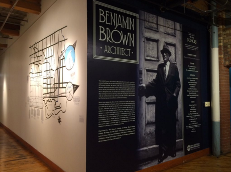
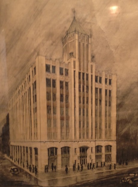
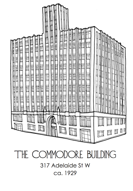
My illustration of the Commodore Building on Adelaide. Unlike Benjamin Brown, I didn’t use a ruler!

Looking at Toronto through the lens of a single architect is an opportunity to make connections between the city’s disparate neighbourhoods and styles. Benjamin Brown’s designs range from the Art Deco towers downtown to utilitarian garages in the west end, storefronts on Bloor and Georgian, Tudor and Colonial Revival houses in midtown.

Through the work of Benjamin Brown, an intelligible thread runs through Toronto, a city indebted to the grandeur he helped established at the turn of the twentieth century.

See the exhibit of Benjamin Brown’s work at the Urbanspace Gallery on the ground floor of 401 Richmond, now until April 23.


This slideshow requires JavaScript.

Benjamin Brown is one of Toronto’s most important, but least well known architects.

Practicing in the 1920s and 30s, his Art Deco towers defined the Toronto’s Garment District when the city was emerging as a modern metropolis.

Beyond the downtown core, Brown’s work can be found throughout the city – store front designs, residential homes, synagogues and community centres.

To illustrate the expansiveness and character of his work, the Ontario Jewish Archives commissioned me to illustrate 15 of Benjamin Brown’s buildings, along with a giant map featuring  a selection of his commissions.

The illustrations and map are up at the Benjamin Brown exhibit at the Urbanspace Gallery on the ground floor of 4o1 Richmond until April 23.

Enjoy digital versions above and samples of the map below, and be sure to check out the exhibit to see the mastery of Brown’s plans and renderings in person!

IMG_9388IMG_9379


Over the summer, I’ve illustrated a few maps for my friends over at Craft Beer Passport, encouraging its users to fulfill the passport’s motto: “Explore Beer Through Toronto | Explore Toronto Through Beer”.

Each map takes cues from its neighbourhood and is themed accordingly. Downtown Patios is a film noir-esque jaunt through Toronto’s most Gotham like quarters. The Train-Hopper is inspired by the train tracks that dominate Toronto’s west end, especially the Junction. Day at the Beach and The Danny are pure explorations of the Beach and the Danforth East, while The Cozy Date crawl indulges in the whimsy of Bloor West.

Enjoy the maps and happy exploring!

Downtown+Patios

Train+Hop-per

The+Beach

Danny+Map_colour_2

Cozy+Date

Screen shot 2015-05-01 at 3.16.16 PM

As part of Rising Tide Toronto‘s Earth Day Action to Stop Line 9, I illustrated a map showing how disastrous a pipeline failure would be for the city’s waterways.

Enbridge plans to have Line 9 operating by June, despite the fact that the legal challenge by the Chippewas of the Thames First Nation has yet to be heard in court and despite the City of Toronto’s recent motion requiring safety valves be installed to protect Toronto’s waterways.

10712800_392048517619163_3101984277106453001_n

Toronto is a city of ravines and river valleys — and it needs a vast system of bridges to stretch over them. While these bridges are built to maintain the integrity of our famous grid, they inadvertently create amphitheatre like architectural spaces that beg to be explored, along with other overlooked parts of the city. Likewise, Toronto is filled with interesting humans with captivating narratives who need a space to share their stories.

LW LogoWith this in mind, my partner Natalie Amber and I began hosting the Learnt Wisdom Lecture Series last Fall. Building on the success of 2013’s Under the Grid concert, Learnt Wisdom invites attendees to “explore the city as we explore our hearts”, by holding story telling events in interesting and overlooked spaces across Toronto.

LW_1_Things Your Parents

Each event features four speakers from a diversity of backgrounds, sharing stories inspired by a set theme. The event is accompanied by an illustrated map showcasing the lecture location, and a short walking route from a set meeting point. While Natalie waits with the speakers at the lecture location, I go and meet the attendees at the meeting point, creating a psychogeographic procession as we make our way to the lecture space.

At the beginning of each event I introduce the space by sharing a brief history, including First Nations history, lost rivers, poignant events and quirky trivia.

Mount Pleasant Bridge

The first Learnt Wisdom Lecture was held under the Mount Pleasant bridge along Rosedale Valley Road. Rosedale Valley Road, voted the best route for motorcycling by YouMotorcycle.com, is in a ravine created by the now buried Castle Frank Brook. It was the site of the first Lieutenant Governor of Upper Canada’s mansion (Castle Frank), and one of the city’s first breweries.

LW_1_Map_Drotsztain

Inspired by the theme Thing Your Parents Never Told You, our lecturers regaled attendees with stories of finding roots, overcoming narratives of strength, and breaking into hotels. Sipping pay what you can mulled cider, it was an absolute pleasure to take in stories under the breathtaking arches of the Mount Pleasant Bridge.

LW_Humber

LW_Over_Poster

The second lecture, this time in the afternoon, took place under the soaring Dundas Street bridge by the beautiful Humber River. Despite the Humber’s eden-like qualities, many Torontonians have not explored this verdant paradise – a linear park that stretches, only somewhat interrupted, from Steeles all the way to the lake. I was excited to share one of the most breathtaking, but least known pieces of infrastructure in the city with friends and strangers.

LW_Map_Drotsztain

Before getting to the lectures inspired by the theme Over the Hill, I shared a brief history of the site with attendees, including the Humber’s importance to First Nation’s as a trading route, the River’s role in the naming of Toronto, and the flooding caused by Hurricane Hazel, remembered vividly by Anne Michaels in her Fugitive Pieces. The lecturers shared stories of epic travel, bicycle-based endurance, and the struggle of moving on from unhealthy situations. As the river flowed, we drank spiced chai under the soaring arches of the beautiful Dundas bridge.

Learnt Wisdom Lecture Series has been a huge success. Each event has brought out impressive crowds, and a chord has been struck by an event that combines storytelling and urban exploration. Natalie and I appreciate the support of our friends and collaborators in these early stages of Learnt Wisdom, and thank you for coming out!

For now, Learnt Wisdom Lecture Series is taking a little hiatus until the new year. We are actively looking for appropriate indoor space for our next instalment. This is harder than you may think! Many of Toronto’s indoor spaces are privatized, and require lots of money or business insurance to use them. Learnt Wisdom Lectures has neither. But we won’t give up our search, and hope to announce our next lecture somewhere in the PATH system, 2015.

See you there and then, under the bridge, in the ravine, or under the grid! 

DSCF9966

Geomancy_Card

We are all implicated in the city. We cannot opt out of geography.

Geomancy, fortune telling with maps, looks at the routes we most commonly traverse through the city, suggesting ways topography, ecology, history, cardinal orientation, infrastructure and the grid affects our being.

Geomancy was first presented at the Algonquin Island Christmas boutique. It will appear next at Long Winter, Year 3, Vol. 2, this Friday December 12 at the Great Hall.

Come, explore your geography with me. Let’s try to understand the intersection of landscape and spirit.

Geomance

Mobility Rings

Check out this map I made for Charlie’s Freewheels to publicize the impact their programming has on empowering youth in Toronto on the occasion of their Indiegogo campaign. It shows, quite simply, that your world it quite small if you walk everywhere, and you can farther, faster by bike. Bikes make the city smaller for everyone – and that makes opportunities for connection and engagement with the rest of the city.

WR_Map2

White Rabbit is a week long artist residency on the shores of the Bay of Fundy. Every year, 16 artists are invited to explore Red Clay, and engage in process-based art making in response to the landscape.

The residency culminates in a music and art festival, where visitors are invited to explore the land and enjoy the manifestations of the residency, including installations, workshops, performances and audio-tours. 

Every few years, the organizers of White Rabbit invite an artist to create a map to help festival goers find their way around the land to projects that are often deep in the Red Clay woods. Past map-makers have included Jayme Melrose, Sarah Burwash, and Chris Foster — artists and individuals who have been highly influential to my way of living and art practice. I was honoured to join the ranks of these esteemed creators, having been invited to be the resident Red Clay cartographer this past White Rabbit. It was a pleasure to see people navigate the festival with a map I had created!

whiterabbit

Festival goers figuring out where they are this year at White Rabbit


Logo

Toronto’s craft beer scene is exploding. In response, local entrepreneur Michael Stulberg came up with the Craft Beer Passport. For $20, the passport gives you access to $2 craft brews from bars around the city. Just like that you get cheap, delicious beer, support local bars and breweries, and are encouraged to explore Toronto!

The Craft Beer Passport crew used my services as an Urban Geographer to determine how to divide the city into neighbourhoods — Torontonians’ local pride can get mighty fierce, and calling something the wrong neighbourhood would not be good. On top of that, I illustrated a poster for a Pub Crawl that happened in June as part of Ontario Craft Beer Week. Proceeds went to Not Far From the Tree, an organization that redistributes urban fruit harvests.

The map had to be a usable wayfinding device — but  I managed to sneak some local character in there. Enjoy! 

CBP_Map_2_Colour