Archives for category: north-west europe

Every day this month, I’ve biked from central Malmö to Alnarp, as small rural community just outside the city and the home of SLU, the university I’m currently doing an exchange at.

The bike ride takes about 45 minutes, and in this short distance, I pass through many distinct landscapes: neighbourhoods within Malmö itself, a highway interchange zone, industrial Ärlov, a bird reserve, and rural fields, all before getting to Alnarp.

Despite being within biking distance, because of all these landscape changes, Alnarp feels very, very far away from Malmö. And phenomenologically, it is. As I’ve explored before in past posts, distance matters less than feeling in determining how “far away” a place is.

Like the short ferry ride between downtown Toronto and Toronto Island, whenever a change in material reality is experienced, places seem very far away, no matter how far the distance.

And on my bike ride from Malmö to Alnarp, I experience many changes in material reality.

The city drops out, and then I peddle through the land of highway interchanges. The bike path weaves up, down and through bridges and overpasses, floats over the expressway and in between unkempt shrubs. At night, hundred of rabbits scurry between the vegetation, lending this landscape an even more ethereal quality.

IMG_9054.JPG

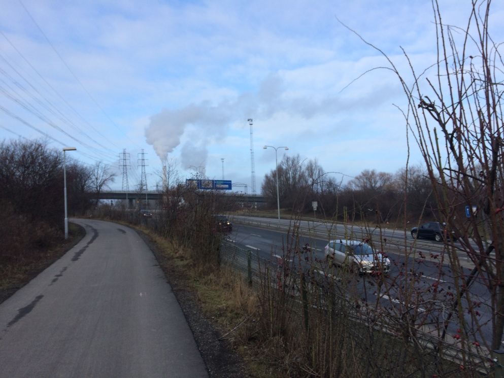
The land of highway interchanges

Then, there is the land of the sea – the bike path borders a bird reserve, and the horizon extends infinitely. The smell oscillates from the salty murkiness of the coastline to an almost candy-like scent from the nearby garbage processing plant. The matted grasslands and water channels, the hawks, ducks, geese and crows flying around – this is a wholly distinct material reality where my thoughts expand as my breath shortens to keep up with small inclines.

img_9058

The land of the sea

Finally there is the land of the fields.  Naked patches of deep black soil envelop the bike path, and linear bands of trees, bent in the wind add directionality to this change in material reality.

img_9063

The land of the fields

I arrive at Alnarp tired, dazed and feeling distant. Despite this being the distance of roughly the distance of Toronto’s Ferry Terminal to Davenport Rd  and Dufferin (still very much in the city, and a commute I made often last I lived in Toronto), the many changes of material reality make Alnarp very much a distinct place, and my life in Southern Sweden is characterized by inhabiting many places at once, despite occupying the footprint of a tiny portion of the City of Toronto.

Screen Shot 2017-01-27 at 8.26.03 PM copy2.png

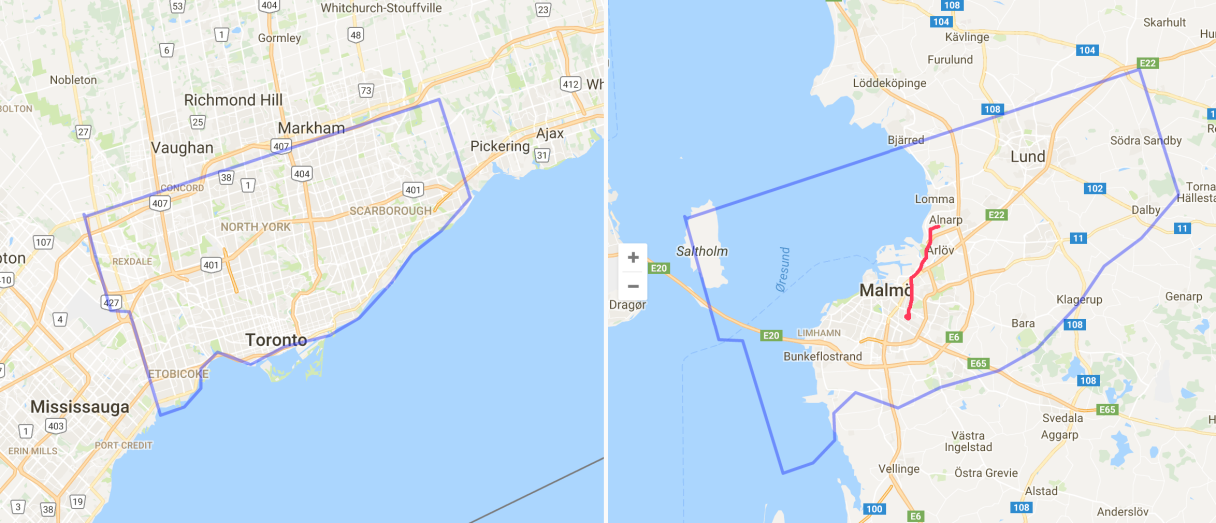
Map comparing distances in Toronto and Malmö – the red line represents my bike ride, and the short distance that takes me through so many changes in material reality. 

malmo

I’m from Toronto – Grid City. I like a good orthogonal city plan. A city where North is up, South is down, and East and West, are, you guessed it, side to side.

Well, Toronto is not exactly a perfect grid. As Dylan Reid has explored on Spacing, Toronto is in fact a series of micro grids, stitched together, with some exceptions for topography that even the imperially-decreed gridded city plan couldn’t ignore. But that’s a fine detail, a technicality. The macro grid – the one that made up of Toronto’s major streets –  is based on a series of 2km-spaced concession lines, and it defines how the city is organized.

Growing up in Toronto, City of Grids, I think, is part of why I have such a keen sense of direction. People in Toronto, they use cardinal directions to direct people where they need to go. “Go north on Bathurst, then west on Eglinton” they’ll say, and it makes perfect sense. As a result, I have North permanently etched into my mind as essential to understand where I am.

Even when a city’s grid doesn’t match the cardinal directions, a perfect grid means that people use cardinal directions anyway. In Montreal, what people call North is in fact more North-West. In Guelph too. Rather than constantly say “go north-west, then south-west”, people have collectively adjusted the meaning of north in the local context.

Other cities – where the grids aren’t so reliable – aren’t like this. In Halifax, an otherwise perfect grid bends around the Citadel and Common. The grid dissolves into spaghetti as the straight elements (the roads), navigate rounded elements (the Common). As a result, people are more inclined to say “Go up Robie”, “Go down Agricola”, instead of cardinal orientation, and it just makes more sense.

halifax

In Newfoundland, at least, according to my friends, directions are much more story-based than cardinal- based.  St. John’s is pretty loopy city, and the small downtown grid quickly dissolves to negotiate the city’s various hills and steep slopes. Here, instead of “Going north on Prescott Street”, directions are more based on stories, and landmarks. “Go past Rosie’s Convenience, and make a left”.

st-johns

As you may know, I am currently living in Malmö, Sweden, and will be exploring the Skåne region for the next five months.

Malmö is especially disorienting to me because, as this post’s title suggests, the city is almost a grid, but, it’s not quite a grid. Two streets that I think are parallel end up veering away from each other, and intersecting at other points, as the map below highlights.

malmo2

I’ve explored how different cities present different flavours of disorientation, and as kinds of disorientation go, this might be the toughest challenge so far. I’m so sure I know where I am, using my Toronto infused griddy-knowledge, only to be constantly lost, and going in the wrong direction. In almost making sense as a grid, but then not being a grid at all,  it has been a humbling, getting lost experience (and this is a good thing).

This posts title was inspired by The Almost Nearly Perfect Peoplea less than perfect exploration of Scandinavian culture by Michael Booth. 

your-urban-geographer
See also

I love the way many European cities’ train stations are woven directly into the fabric of the streets.

I mused about this with regards to the ticket-free barrier to the platforms at Amsterdam’s Centraal Station, and now that I’m a regular GO train user, can appreciate that Toronto’s Union Station has a similar system.

But what’s different about Union Station is that the platforms feel very cut off from the city. They are a space apart, separated by concrete gangways, claustrophobic staircases and glass doors.

Copenhagen’s Central Station is different: wide open staircases connect the platforms directly with the street, and there’s a seamless transition from station-space to city-space.

I think the benefits here are more intangible. There’s a feeling of accessibility to a train system that presents itself so openly at street level. It injects dignity to the potentially inhumane scale of rail infrastructure.

Looking forward to investigating more of northern Europe’s rail-street connections.

This post originally appeared on Spacing Toronto 

To the delight of many, it was recently announced that the TORONTO sign in Nathan Phillips Square will remain in front of City Hall until its structural expiry date of 2016, when it will be replaced by a more sturdy set of letters.

Installed as part of the Pan Am Games, the sign is one of the most popular legacies of the event. It is a highly photogenic addition to City Hall, offering the perfect spot for selfies amongst the sign’s many Ts Rs and Os.

The old saying is that “life imitates art” — but with the immense popularity of the TORONTO sign, it might be more accurate to say that these days, “life imitates graphic design.”

The dominance of graphic design culture — researchers now estimate we’re exposed to5,000 ads per day, and the number of graphic designers in Canada has increased rapidly over the last few years — has reached its apotheosis in the 3D TORONTO sign. Photos of Nathan Phillips Square and City Hall now automatically take on the look and feel of a highly designed poster.

The TORONTO sign is part of a global trend of huge letters in prominent public space. It’s most direct precedent is the I amsterdam sign. Situated behind Amsterdam’s Rijksmuseum since 2005, friends visiting the Netherlands are almost guaranteed to post photos of themselves climbing the iconic red and white letters. The ONLY LYON sign followed in 2010 and the BUDAPEST sign in 2014. It was only a matter of time that big font would come to Toronto.

I amsterdam

ONLY_LYON_Place_Bellecour

Budapest sign

This isn’t the first time art has affected landscape. Big, wooded parks with meandering pathways like High Park in Toronto, Central Park in Manhattan, and Mount Royal Park in Montreal, were all inspired by Romantic landscape paintings of the late 19th century. Spreading as a park format worldwide (most major North American cities have an equivalent), these pastoral parks are a reflection of what people in burgeoning industrial cities needed from their landscapes — and how they idealized them.

But the blending of graphic design and landscape architecture is evidence of a new kind of relationship we’ve developed with our civic spaces. No longer pastoral retreats à la High Park, with our smartphone cameras always close at hand, a landscape must be striking and photographable to make an impact. And giant, Instagram-able letters are the most effective way to communicate the core of most messages on social media — “I was here.”

Spadina Avenue, closed to traffic - Pedestrians and Streetcars mixing. Image courtesy of BlogTO

Spadina Avenue, closed to traffic – Pedestrians and Streetcars mixing. Image courtesy of BlogTO

Love it or hate it, Nuit Blanche delivers the spectacle of Toronto’s streets crammed full of people. With the sidewalks at capacity, and many streets closed to car traffic, we are treated to a hyper-urbanized version, 24/7 version of Toronto. Every October, the city becomes fully animated — perhaps a preview of things to come if population growth keeps apace in the next 50 years.

This year’s edition of the all night contemporary arts festival included the addition of new zones. Along with Fort York and City Place, Spadina Avenue was closed to traffic, and many artworks were displayed along the street.

The experience of Spadina closed to automobile traffic was highly enjoyable, providing a new perspective on the potential of this thoroughfare. The broad avenue, with dedicated street car tracks running down the middle, naturally lends itself to being a pedestrian boulevard. The dynamic was reminiscent of Las Ramblas in Barcelona — a boulevard famous for its walking culture.

I noticed, however, Torontonians struggling with the concept of a street being set aside for pedestrians and streetcars. Though barricades and traffic police were present to ensure that people would not cross the tracks when streetcars were coming, people kept on running through the tracks at the moment a streetcar was approaching.

The mix of a pedestrianized thoroughfare and streetcar tracks reminded me of some of my favourite street designs in Europe, where this kind of configuration is more common. As a past post explored, along Leidsestraat, a pedestrian-only street in Amsterdam, people freely walk along the tram tracks until one needs to pass by. The street is both a tram track and a pedestrian walk way and works beautifully. In Manchester, dedicated Tramways line the central Piccadilly Gardens, a bustling square. The square’s surface covers the entire area, with only slight demarcation of where the trams run, other than their tracks. The flow of this place is lovely — as pedestrians cross the square without stress, and avoid the trams when they come every-so-often. And when they do they blow their gentle whistle and all the senses have their outlet.

Making room for trams as the need arises, on Leidsetraat in Amserdam. Image courtesy of Urban Capture

Making room for trams as the need arises, on Leidsetraat in Amserdam. Image courtesy of Urban Capture

Pedestrians share space with trams and their tracks in Manchester. Image courtesy of ManchesterHistory.net

Pedestrians share space with trams and their tracks in Manchester. Image courtesy of ManchesterHistory.net

In Toronto, where we’re not used to this kind of shared space (yet), things were a little more challenging. Perhaps the presence of safety officers and infrastructure contributed to the tension, and people would have been better of interacting with the streetcars organically.

In any case, I was delighted to experience a step toward shared flexible space in my own Toronto. Little by little, we are demonstrating that streets are not only for cars, and can host multiple uses, complimenting and accommodating one another as the need arises.

ASEED MAP_Front

ASEED is an activist organization based in Amsterdam that targets the structural causes of environmental destruction and social injustice.

Much of their work in the Netherlands focuses on food security, and the averse effects of the industrialization of the food system. Their work involves education, workshops and events like the yearly March Against Monsanto march in Wageningen.

Earlier this year, I designed and illustrated a map of the world, exploring the negative effects of GMOs and resistance to them all over the planet. It was a fantastic project, diverse and challenging. The goal was to communicate a dense amount of information in an accessible and engaging visualization. A map is often the best way to achieve this!

Click on the map below for a full resolution version, and support the resistance to GMOs!

ASEED MAP_Front


ASEED back


I began thinking of Amsterdam as a watery place when I was living there last year.

The following is a simpler manifestation of the thoughts that form the basis of this piece – thoughts that had my head spinning as I biked along the city’s waterways. 


watery 2

No one told me that Amsterdam was built on the bottom of the ocean floor. I had to piece it together myself – and I only realized after a few months of wandering around.

With canals, constant rain and a maritime tradition, I knew that Amsterdam was a watery place. But I didn’t quite expect a city at the bottom of the sea.

My first clues were in the dialect. Dutch is a water based language. The next tip-off was, despite being several kilometres inland, the presence of salty air.

It finally became obvious when I started paying attention to city construction crews. They would unravel interwoven brick roads to reveal the sand just beneath the surface of the city. When an entire road is repaved in Amsterdam, a beach appears between the two sides of the street.

Taking advantage of these exposed patches, I would put my hand on the ocean floor and feel the sand. I found sea shells there, under the streets.

In Amsterdam, there is sand everywhere. Piles of sand sit along the canals. A fine layer of sand covers the streets and sidewalks.

Along the bigger canals, I would watch long flat boats, carting piles of sand along the country’s internal waterways.

I hear a lot about Dutch land reclamation projects making land where there was once water.

When it rains in Amsterdam, it feels like the process is being reversed. Hovering above the sea floor, water reclaims the land and air above it.

watery 1


This piece will be appearing in the forthcoming issue of Hey Now, a small batch magazine published in Wychwood Heights, Toronto, Ontario 

blogosphere-hi-res1-scale1

In an effort to start a conversation with the proliferation of research occurring outside of the academy and facilitated by the internet, the University of Manchester and Hunter College created the Alternative Mode of Scholarship Competition.

Here was the call out:

In recognition of the increasingly diverse ways in which researchers disseminate their research, the UGSG Alternative Mode of Scholarship Competition Committee solicits submissions of blogs, videos and websites by an undergraduate or postgraduate student or group of students. The winner/s of the award will receive $200. Submissions should be in the form of a URL address plus no more than 300 words explaining how the submission contributes to an understanding of urban geography. 

I was especially excited to enter the contest, as research outside of academia is exactly how I define the activities of this blog. The internet has truly facilitated my emerging career, and has connected me with collaborators and like minded people world wide. The University of Manchester also happens to be the home of one of my favourite geography professors, Erik Swyngedouw, of the Urban Political Ecology literature.

Entering the competition was an opportunity to define my approach to blogging, and is one version of how perceive my contributions to Urban Geography, and its role in the world.

I didn’t win the scholarship, but I present to you my submission anyways. Enjoy.


My blog, TheUrbanGeographer.Wordpress.com, has been an invaluable venue to design my own research programme after the completion of my Undergraduate degree in Urban Geography at McGill University.

Using the blog, I have extended Swynedgedouw and Heynen’s theories of Urban Political Ecology(2003). Via art work, photography and writing, I have applied their theories to Toronto, a city that has an evocative relationship with its ecology.

One project that has emerged has been an exploration of Bioregionialism and its application to Toronto. Carolinia is a hypothetical post-national region that encapsulates the northern tip of the Eastern Deciduous forest, southern Ontario and Upstate New York. It is a region that shares watershed, commutershed, culture and ecology. I presented my research at the 2013 Urban Ecologies Conference, arguing that emphasizing Toronto’s ecology in its identity is an important step toward achieving social and environmental justice.

Though inspired by academic research, my blog has become a venue for crafting theories that are very accessible. The blog has also encouraged the use of visual aids (photographs, drawn maps, diagrams). Clarifying my writing and making it more accessible has lead to my writing for other blogs and magazines such as SpacingVolume and the Pop-Up City.

Perhaps the blog’s greatest strength, however, is that it exists within a network. My blog has connected me to other academics, planners, entrepreneurs and artists engaged in the topic of Urbanism. We are all working toward inclusive and sustainable city building. The blog has lead me to a number of employment opportunities including working on the establishment of a Greenbelt for Halifax.

I will continue to blog as my career grows and transforms. Whether I am engaged in academic, artistic, economic or political work, my blog is an invaluable and connected depository of my theories, thoughts and practice.


Exciting news, readers!

Your urban geographer received a 2013 TOmaps Awards from the TOmaps sub-Reddit!

CornishBin, the sub-Reddit’s fantastic moderator put together a list of the year’s best Toronto-inspired maps. The list includes “Best Animation”, “Prettiest breakdown of Toronto’s diversity” and “Best TTC-related map”, naming my map Torontodam “Best Mash-Up” (see below). The map transposes Amsterdam neighbourhoods onto Toronto, matching them based on corresponding geography and culture.

reddit 2013

The list showcases the best of the cornucopia of cartographic treasures that the TOmaps sub-Reddit showcases on a daily basis. A hearty congratulations to the other award winners, and a big thank you to CornishBin for being such a thorough curator of all things Map-TO.

torontodam5

Here’s to a mapful 2014!

london-platform-park

A new project in London proposes converting a bridge over the Thames into a lush, green park: London’s High Line over the river.

I adore this idea. The romance of a bridge is inherent, and we do them a great disservice by purposing them for one simple task: moving cars. The proposed green-bridge would be built across the Thames linking and enlivening two newly built neighbourhoods on the river’s edges.

Screen shot 2013-11-12 at 11.18.34 PM

The garden-bridge proposal, by Heatherwick Studios, reminds me of a bridge that crosses over Toronto’s Don Valley (and its parkway) that I’ve fantasized converting into a similarly spanning oasis.

From the perspective of driving down the Don Valley Parkway, the bridge already looks wild, with wide green spaces of brush, bushes and trees running along its sides. From satellite imagery I’ve determined that indeed, train tracks run through its middle. Viewed from the road beneath, however, it looks as though a park stretches across the Valley — linking east and west as if protesting the expressway that carved a permanent barrier between the Valley’s edges.

ceramic bowl

My parents house is full of stuff. It is brimming. Every room is stacked with old magazines, books and chachkas —  trinkets, never-used glasses and teapots. Old papers of every sort.

As part of this propensity for piling, my mother likes to put large empty ceramic bowls all over the house. Once a bowl is set down on a table- or countertop, it makes a tear in space, creating a vacuum that gets immediately filled with all sorts of the above-mentioned old papers/trinkets/never-used teapots.

My brother get furious at the existence of these bowls. His theory — which I back — is that the useless stuff would not accumulate if the bowl hadn’t created the space for accumulation. Simply: placing a bowl creates a vacuum in space. Refrain from placing the bowls, and  avoid an accumulation of useless objects.

stand alone

To bring this post from the realm of private domestic space to public urban space:
In Amsterdam there is a shortage of bike parking spaces. As a result, it’s common to leave your bike free standing and double locked (front wheel and back), not attached to any pole or official bike parking infrastructure in particular. You just leave it standing there. 

Of course, it’s riskier to park your bike this way — free standing and vulnerable — than affixing it to a solid pole or bike stand. But poles and bike stands run out quickly, and you often have no choice but to let your bike free flow. 

There are strategies to make your bike blend in, to make it seem like it is attached to something when it is in fact not. The most common of these strategies is to neatly line up your bike with an existing bike rack to make it seem as though it is attached to the bike rack, when in fact it is floating freely beside it. 

stand alone 2

With this strategy, there is a certain street-wisdom that follows:  you should always park you bike where others have parked their bike, making your bike less of a target, and diminishing the chances of it being stolen.

Sometimes, people line up their bikes spontaneously to create fake bike racks – strength in numbers makes the deception more effective. But this has to start somewhere – someone has to be brave enough to leave their bike free standing, floating, easily taken in the middle of a sidewalk or square.

Like the bowls that fill with useless objects in my parents house, leaving your bike free standing in the middle of a side walk or street creates a vacuum in space, and leads to the accumulation of more bikes.

So, if you’re in the Netherlands, give it a try! leave your bike on its own, free standing , and when your return, a neat fake bike rack will have formed around it. Like a rock that collects moss in a moving river, leaving  your bike free and on its own in a square or on a street will create a bike vacuum, no doubt.