Archives for category: infrastructures

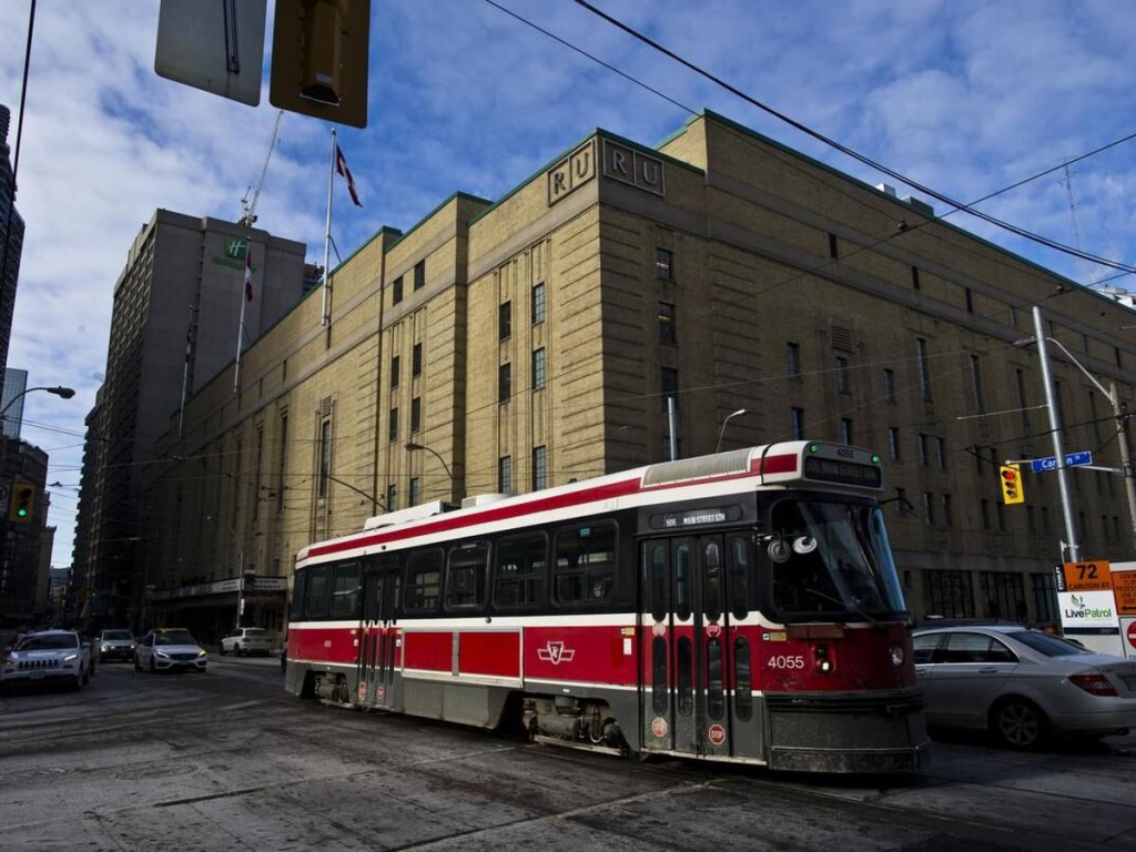
This piece was found in an old yahoo email account. It’s an itemized list of the sents/sounds/sites of Toronto’s old streetcars, written in anticipation of their retirement in 2024

From the outside

The geologic thunder
The ca-clunk ca-clunk
Not being able to see them from a distance
Their green lights fading into traffic lights. Their weak front headlight barely visible as it trundles into oblivion and obsolescence
Stuck behind a turning left car

From the inside
The shuttered click of the back doors, the air releasing as they shut
The squeak of the back motor
The complete silence when that motor turns off
The buzzing sound of the street car moving forward
It’s forward momentum
It’s gentle ascending tone and descending tone when slowing down
The ding of someone pulling the rope to alight
The barely lit stop request sign
The friction of the sliding window
The keep arm in medallion
The availability of the driver, sharing the same space
The release of air as the front doors open
The clink of change in the fare collection box and the drop off them all into the main pile
The thud of shoes on the plastic floor and up and down the stairs
The dinging gong as two streetcars pass each other
The fierce horn at a errant car passing it’s open doors, fiercely defending the street
The click of the back door steps confirming they will open after a slight delay

The too hard to reach pully strung stops

This reflection is cross-posted on the SLU Urban Readings group. According to SLU, “Urban Readings connects a small team of chroniclers across the hemisphere with the mission to spot and comment on relevant articles connected to the urban realm in international press. The group of writers consists of academics from various fields intersecting the urban, with insight in current discussions from around the world.” Check out more readings here.

The COVID-19 lockdown hit Toronto like the eye of a hurricane. While the virus was causing chaos for our ill-prepared healthcare system and brought the economy to a precarious standstill, it all felt strangely still on the streets. An eerie calm descended on Toronto as cars evaporated from the city’s typically clogged roads and highways, the sudden lack of motors revving and cars whooshing created a deafening quietness.

Many were quick to see that the empty roads offered an opportunity to create a larger pedestrian realm so people could navigate the city while maintaining safe distances from one another to prevent the spread of COVID-19. After several weeks of advocacy for Toronto to open lanes of traffic to pedestrians, politicians and public health officials remained reluctant to do so, perpetuating a car-oriented logic that defines the planning and management of most North American cities. While cities around the world — including many in Canada — were opening hundreds of kilometres of empty streets to pedestrians, Toronto remained stubborn on the status quo. While advocacy was reaching a fever pitch amongst urbanists online, it had yet to pierce the mainstream discourse.

I am a member of the Toronto Public Space Committee and an organizer of its Art Subcommittee, exploring how we can use art to advance public space advocacy. At a virtual meeting, we realized that our collective effort to create more space for pedestrians in Toronto during COVID-19 and beyond needed something to rally around (and of course, a hash tag.)
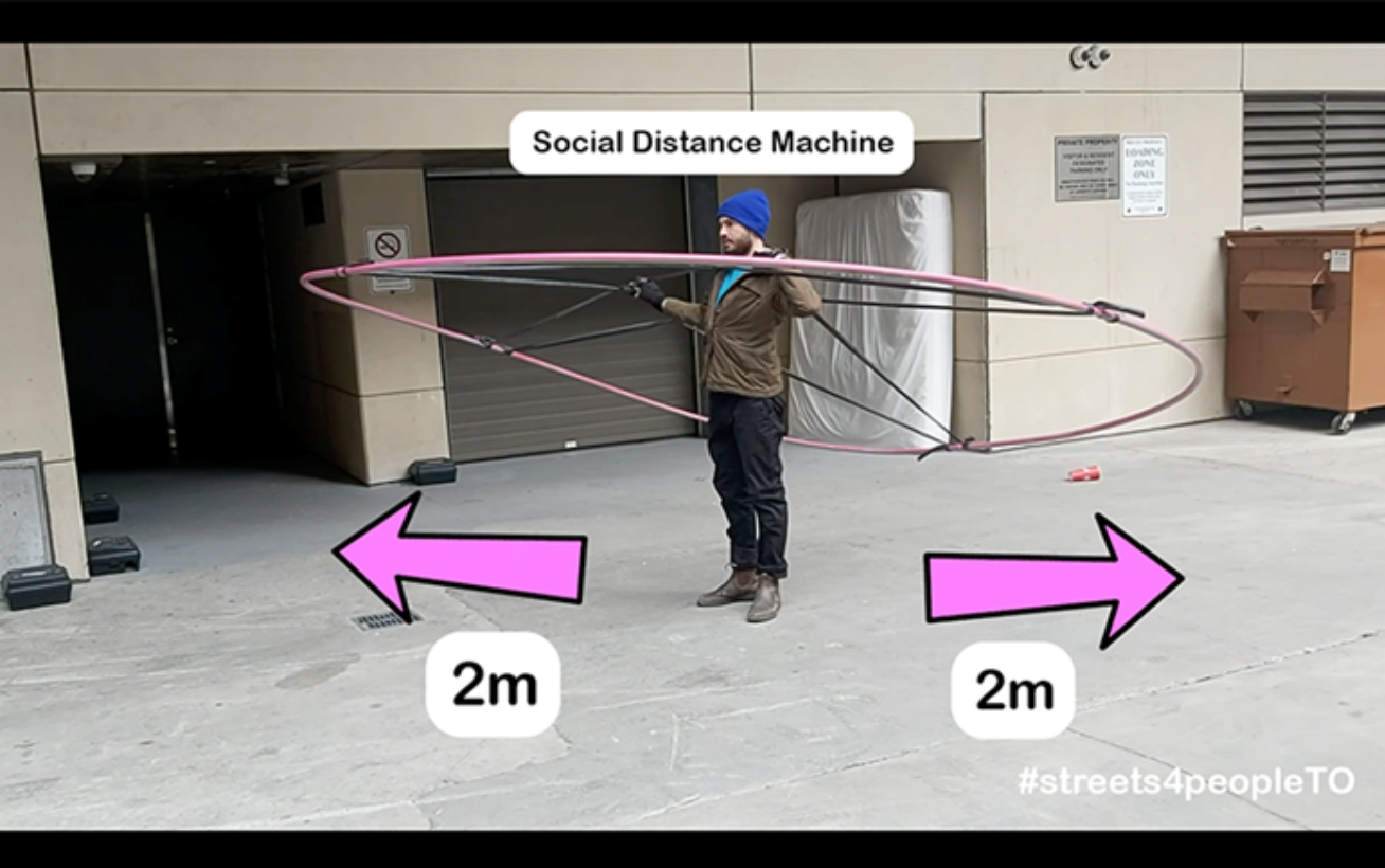
Screen Shot 2020-05-19 at 1.58.32 PM

The Social Distance Machine

With the help of artist and musician Bobby Gadda, we created the Social Distance Machine, a giant wearable hoop made out of plastic conduit piping and bicycle inner tubs to clearly demonstrate how large 2m really is — the recommended distance to stay apart to prevent the spread of COVID-19 — and how little space in Toronto is allocated to pedestrians to maintain that distance from others. We wanted to create a video that was humorous and highly shareable, to contribute a lighter tone to a very serious conversation. We released the video the morning of April 13 with #streets4peopleTO and by the end the day it had gone viral around the world, resonating with other cities that were facing similar struggles as they demanded more space for pedestrians to navigate their streets safely.

Toronto’s politicians and public health officials responded slowly. Despite endorsements from major thought leaders and an editorial from the Globe and Mail, the City of Toronto remained reluctant to accept the new reality that people were going to be going outside, and that the city’s infrastructure had to be adapted to facilitate pedestrian movement safely.

We Are Not “All in This Together”

A common phrase we’ve heard during COVID-19 is that “we’re all in this together”. The message is everywhere: posted in shop windows, on social media, in advertisements, and endlessly repeated in politicians’ speeches. The immense gap between those who have the time, space, and resources to safely navigate the pandemic and those that do not demonstrates that this catchy phrase is far from the truth. COVID-19 has emphasized the inequities and issues that existed before the pandemic, rendering them unignorable. As Paul Taylor, the Executive Director of Foodshare, a food security organization in Toronto, wrote in an op-ed to the Toronto Star, “many of the requirements necessary to ensure that we shelter in place are based on the belief that everyone has a smart phone with a generous data plan, ready access to computers and wi-fi, a car, and a credit card”. According to Taylor, the pandemic has most profoundly affected “the millions who were food insecure before the virus hit”.

In terms of urban design, COVID-19 has emphasized pre-existing mobility inequities including the ability to navigate the city safely. In a recent article in Spacing Magazine, Tricia Wood, a professor of Geography at York University writes that “mobility is everything in a city”. According to Wood, “the more freedom of movement you have, the more privilege and advantage you have”. Freedom of movement includes the speed you can get from A to B, access to physical resources and social infrastructure, safe ways of getting around, and safe places to dwell. Before the pandemic, mobility was often limited for those who are disabled, racialized, homeless and queer. COVID-19 has emphasized these pre-existing inequities, while the wider population has begun to understand what restricted mobility feels like.

While the Social Distance Machine went viral and contributed to advocacy for more pedestrian infrastructure during COVID-19, it failed to address the unequal experience of mobility throughout Toronto’s disparate communities and geographies. The Social Distance Machine video demonstrated the inability to navigate Toronto’s central sidewalks safely, but it overlooked what author and placemaker Jay Pitter has termed “forgotten density” in a recent essay in Azure Magazine. Urging us to look beyond the overly studied city centre, forgotten density includes tent cities, suburban social housing, shelters, favelas, temporary foreign worker dormitories, Indigenous reserves, and prisons. Forgotten densities are contrasted to what Pitter calls “dominant density”, which are “designed by and for predominately white, middle-class urban dwellers living in high-priced condominiums within or adjacent to the city’s downtown core.” According to Pitter, these “myopic, privileged framework[s]” of density refuse to distinguish between good density and bad density, failing acknowledge how income, race and disability effect our experiences of urban space.

Within these forgotten densities, residents “are scared to leave their apartments for essential reasons because they can’t practice social distancing in cramped entranceways, elevators and laundry rooms.” Vulnerable populations are at more risk in small apartments without enough space to quarantine, and so-called “front line workers” such as those employed at factories and grocery stores cannot afford to quarantine at home. They are thus more likely to be exposed to COVID-19 than those that have the ability to work from home.

Due to the majority of the population working from home, the Toronto Transit Commission (TTC) has seen a 75% drop in ridership. Sean Marshall, an active transportation advocate and geographer, recently mapped the bus routes that remain crowded during COVID-19 for Spacing Magazine. He found that the bus routes that connect low-income neighbourhoods to factories in Toronto’s northwest remain overly crowded, preventing riders from practicing safe social distancing.

Advocacy for more pedestrian infrastructure requires the equity lens advocated by Wood, Pitter, and Marshall. According to Stefan Novakovic, the online editor of Azure magazine, “progressive urban advocacy means more than wider sidewalks”.

More than Wider Sidewalks

After several weeks of advocacy for more pedestrian space during COVID-19,  the Mayor of Toronto announced on May 6, 2020, that the city would be opening 50km of streets to pedestrians, while fast-tracking the construction of new bicycle lanes. It remains to be seen where and how these pedestrian streets will be implemented. Using an equity lens, advocates need to ensure a geographically equitable distribution of open streets, ensuring relief is given to people most in need of space to navigate safely.

In New York City, more than 100km of streets have been open to pedestrians in response to COVID-19. According to writer Yessenia Funes in Gizmodo, much of those road closures are within and beside existing parks, with wealthier, whiter communities living nearby. As Funes bluntly puts it: “What about the people who don’t live near parks?” Advocates for more pedestrian space in Toronto and beyond need to ask the same questions as their cities pedestrianize roads in response to the pandemic.

Novakovic acknowledges that advocacy for pedestrianizing streets must include communities outside of Toronto’s downtown core. In line with Pitter’s assertion that we must include forgotten densities as we push for conditions for safe physical distancing, Novakovic identifies specific actions, for example the “immediate funding for elevator repair and building maintenance is needed for the city’s chronically underfunded social housing communities”. Toronto’s social housing has $1.6 billion repair back log; we can pivot from the urgency of COVID-19 to address this long-standing issue. As activists, urbanists, architects, and planners call for more pedestrian spaces in the wake of COVID-19, Novakovic urges that “it must be matched by an equally strong push for urbanism at the margins – and creating space for forgotten communities as city builders”. This assertion of equitable urbanism and mobility must be addressed throughout COVID-19 and and in the new post-pandemic world.

COVID-19 may have exposed the inequities that have always existed in our society. However, it also offers an opportunity for meaningful adjustments to our policies and advocacy moving forward. According to Paul Taylor, the pandemic “has given us an opportunity to reflect on what a just and equitable society could look like, one that is measured by how well it takes care of its most disenfranchised members.”
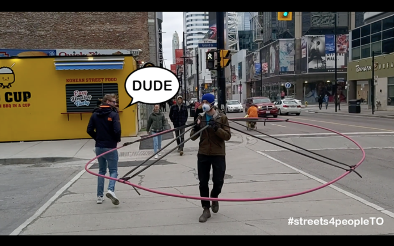
Screen Shot 2020-05-19 at 1.58.24 PM

The Social Distance Machine, a giant wearable hoop made out of plastic conduit piping and bicycle inner tubes to clearly demonstrate how large 2m really is.

Sources:

Funes, Yessenia. “New York City Plan to Close Streets Is Weak As Hell”, in Gizmodo, May 2, 2020

Marshall, Sean. “Mapping TTC Crowding during a Pandemic”, in Spacing Magazine, April 1, 2020

Novakovic, Stefan. “COVID-19: Progressive Urban Advocacy Means More than Wider Sidewalks”, in Azure Magazine, April 25, 2020

Picard, Andre. “It is time for a new mantra: Go outside, but do not congregate”, in the Globe and Mail, May 4, 2020

Pitter, Jay. “Urban Density: Confronting the Distance between Desire and Disparity”, in Azure Magazine, April 17, 2020

Taylor, Paul. “Pandemic has exposed the rifts in our social fabric”, in the Toronto Star, April 21, 2020

Wood, Tricia. “Lessons on urban mobility and inequality during a pandemic”, in Spacing Magazine, May 2, 2020
Cross-posted on Spacing Toronto, and co-written with Brendan Stewart 
Note: this article was written in the summer of 2019, and is reflection on WexPOPS, the pilot project of plazaPOPS, a high-impact, low-cost and community lead approach to enhancing strip mall landscapes in Toronto’s inner suburbs. plazaPOPS emerged from my thesis research while working toward a Masters of Landscape Architecture at the University of Guelph.  You can read my thesis here

WexPOPS is a pilot of the plazaPOPS project, an initiative spearheaded by Daniel Rotsztain, aka The Urban Geographer, and Brendan Stewart (OALA, CAHP), professor of landscape architecture at the University of Guelph, and former Associate at ERA Architects.


In an interview supporting his recent book Palaces for the People: How Social Infrastructure can help fight Inequality, Polarization and the Decline of Civic Life, NYU sociologist Eric Klinenberg points to an idea that many urbanists take for granted, but that the general public may not: “[T]he social life we experience doesn’t exist in a vacuum; there’s a context for it. It can be supported or undermined by the places where we spend time.” In other words, there is a relationship between the design of our physical environment, and the social life it enables, or not.

Klinenberg urges his readers to think about the types of places that foster connections and relationships between people and that build strong communities not as nice to haves, but rather as an essential infrastructure that buttresses the foundations of democracy, inoculating society from many of the challenges that define our current moment. He argues that “social infrastructure” will only become more critical as communities are forced to adapt to the challenges associated with climate change.

Closer to home, the Evergreen Foundation’s Towards a Civic Commons Strategy proposes a similar vision for “a network of public places and facilities that enable communities to learn, celebrate, express collective actions, collaborate and flourish, together.”

Inspired in part by these ideas, we’ve been working for over a year on an experiment to test the potential of creating a type of civic commons/social infrastructure within the ubiquitous strip mall parking lots that define the main streets of post-war neighbourhoods across the country, and which are home to millions of Canadians.

Open from July 5th to August 17th at the iconic Wexford Plaza at Lawrence Avenue East and Warden Avenue in Scarborough, WexPOPS is the result of more than a year of community consultations, planning and design work, and a collaboration involving 19 Master’s of Landscape Architecture (MLA) students from the University of Guelph, graduate business and planning students from the University of Toronto’s Rotman CityLAB fellowship program, a 15-member local working group, and a partnership with the Wexford Heights BIA.

The City of Toronto’s Public Realm Unit, Scarborough Arts, the TRCA, the Arab Community Centre of TorontoMural Roots, the Working Women Community Centre and a number of local businesses who supported the initiative in various ways, including the Kirakou family, who own the Wexford Restaurant and the entire plaza and generously hosted the project.

Funded by Parks People’s Public Space Incubator Grant, generously supported by Ken and Eti Greenberg and the Balsam Foundation, as well as the City of Toronto’s BIA Kickstarter Fund, WexPOPS proposes a big idea: to test the viability of exchanging parking spots for a community gathering space all on private commercial property. It’s a new take on POPS — privately owned public space — and experiments with the city building potential that commercial business owners can exercise by enhancing community life in the neighbourhoods they serve. Hopefully, they’ll also seeing an uptick in business.

Similar strip malls are found throughout Toronto’s inner suburbs and in post-war neighbourhoods all over Ontario and Canada. In many cases, especially in Toronto, the retail remains vibrant and local, serving as important settings for community life, and features numerous restaurants and shops serving food and offering goods from all over the world. The Wexford Heights BIA, a two-kilometre strip running between Victoria Park and Birchmount along Lawrence Avenue East, features over 60 restaurants, and has been celebrated by food columnists as a major dining destination.

The project grew out of Daniel’s fascination with the strip malls he frequented in his youth, culminating in his 2018 MLA thesis at University of Guelph, which was overseen by Dr. Karen Landman and Brendan Stewart. It builds on Daniel’s work as an artist, examining the setting of Toronto’s public life, including All the Libraries Toronto, his documentation of all 100 public library branches in the city, as well as a recent residency at Yorkdale Mall that asserted the centrality of private shopping centres in Toronto’s social geography.

WexPOPS also builds on Brendan’s citizen engagement Tower Renewal work with ERA Architects, including parking lot to community space conversion projects at the East Scarborough Storefront (2010 – 2015) and Ridgeway Community Courts (2015-2017) in Mississauga.

The final design of WexPOPS features a series of modular planters, benches, tables and umbrellas, all clad in marine plywood and trimmed in cedar. Occupying ten parking spaces, the installation creates a comfortable and sheltered ‘room’ in the middle of the parking lot, and frames dynamic views of the strip mall behind. The carpentry was done by Guelph-based Ben O’Hara Design, and all of the components were designed as modules that could be re-configured into different arrangements to suit various future site conditions, and also to flat-pack for easy assembly and storage.

Six design concepts for the project were developed through a series of community workshops by student teams in a graduate community design studio at the U of G this past winter, and the ideas most favoured by the working group and a wider online engagement were incorporated into the final design. For example, one student team developed the colour scheme for the project, which includes vibrant red, orange and yellow and was inspired by the spice markets of the Middle East. Another student team proposed a space of lush and immersive greenery, an idea that resonated in the community and which dominates the final design.

In all, WexPOPS features over 500 plants, which are planted in colour-coded pots: red denoting native perennial wildflowers and grasses, orange for annuals, and yellow for edibles. The pots were created from salvaged recycling pails from the university, and were painted and drilled for drainage. The annuals and edibles were grown in campus greenhouses and donated to the project. All of the native plants, grown by Native Plants in Claremont, will be donated to the Toronto Region Conservation Authority, to be planted in a local stretch of the Meadoway this fall.

Twelve local youth from an after-school program run from the Arab Community Centre of Toronto across the street have been hired as site supervisors, stewarding the site through daily watering, waste management and other set-up tasks.

At night, LED lighting within the benches creates a welcoming atmosphere, and the illuminated strip mall signage creates a dynamic backdrop. During several evenings this summer, including an upcoming event on August 17th, the WexPOPS stage (with a mural designed by Echo Railton and painted by community volunteers) offers music and dance performances by local artists, co-curated by Scarborough Arts as well as urban ecology workshops lead by the TRCA.

WexPOPS is meant to be a hub of social activity for the local community, but also to attract visitors from beyond — a desire articulated by our working group, whose members wanted to `put Wexford on the map.’ The space features a neighbourhood business directory which encourages people to patronize the local restaurants and businesses (and eat takeout in the space), as well as a ‘dot map,’ which prompts visitors to place a sticker on a map showing where they live. This data will help the team evaluate the impact and reach of the project. The signs were donated in kind by CAS Signs Company, a printer located in Wexford Plaza a few stores down from WexPOPS. The ‘Wexford Wish Tree,’ inspired by the shape of the sumac and CNC milled by local AC Waterjet, poses a different question every two weeks and invites visitors to write their answers on a horticultural tag and tie them to the tree for others to read.

WexPOPS may be popping down after August 18, but the proof of concept has already inspired many to reconsider the potential of privately-owned strip mall parking lots as community gathering places, including, perhaps most importantly, the Kirakou family — the property owners and our project hosts. To more concretely determine the project’s impact, the plazaPOPS team is conducting a public life study, modeled on methodologies pioneered by Denmark’s Gehl Architects. We are also studying the impact on parking and local business activity. The Rotman students, guided by Prof. Rafael Gomez, prepared a background study that informed the research design.

Project findings will be published later this year in an exit report, but already, many working in the urban design, community arts, and economic development sectors have noted the potential for applying the plazaPOPS concept beyond Wexford Heights, understanding the value of creating space to support the social life of communities in strip malls across Toronto, Ontario, and Canada.

photos courtesy of Rotsztain and Stewart


More information about the project and its design and planning process are available at www.plazaPOPS.ca and via twitter and Instagram at @plaza_pops. You can reach the team at plazapops@gmail.com.

I love the way many European cities’ train stations are woven directly into the fabric of the streets.

I mused about this with regards to the ticket-free barrier to the platforms at Amsterdam’s Centraal Station, and now that I’m a regular GO train user, can appreciate that Toronto’s Union Station has a similar system.

But what’s different about Union Station is that the platforms feel very cut off from the city. They are a space apart, separated by concrete gangways, claustrophobic staircases and glass doors.

Copenhagen’s Central Station is different: wide open staircases connect the platforms directly with the street, and there’s a seamless transition from station-space to city-space.

I think the benefits here are more intangible. There’s a feeling of accessibility to a train system that presents itself so openly at street level. It injects dignity to the potentially inhumane scale of rail infrastructure.

Looking forward to investigating more of northern Europe’s rail-street connections.

Heritage Toronto commissioned me to illustrate their award nomination forms.

The commission was an opportunity to ruminate on what “heritage” means. Though Yonge & Dundas Square and the Don Valley Parkway aren’t directly the subjects of Heritage Toronto awards, their inclusion on the nomination forms hints toward how we may consider them in the future. Indeed, a decade after Yonge & Dundas Square opened to “consternation”, architectural critics are praising its role in the city.

Don Valley Parkway

Screen Shot 2016-02-15 at 6.12.31 PM

The Hermant Building’s recently restored entranceway

Screen Shot 2016-02-15 at 6.12.26 PM

Community Heritage
Screen Shot 2016-02-15 at 6.12.20 PM

Yonge & Dundas Square
Screen Shot 2016-02-15 at 6.12.47 PM

Short Publication 
Screen Shot 2016-02-15 at 6.12.38 PM

Guelph_Transit_237Guelph is a small city with a small bus system.

Unlike in larger cities where many buses ply the same routes all day with 5-10 minute headways, Guelph can’t afford to do that – there are too few people.

What I initially felt was a bummer — buses every 20-30 minutes at peak times and every hour at other times of day — turned one of the system’s greatest strengths: reliability.

This seems like a major paradox – how can you build a robust transit system by providing less?

Transit planners have a maxim that people won’t adopt public transportation unless its frequent and reliable. In Toronto, it often feels like it’s frequent but not reliable. In Guelph, however, the service may not be frequent, but it is very reliable.

Because the bus comes so infrequently, users are forced to use the schedule to see when their bus is coming. The bus system becomes more like a train system in this way – fixed times when the bus will be coming that you can plan your routine around.

While the buses sometimes detract from their schedule, key points in their routes, like the University Centre and Guelph Central Station, put them back on schedule. At these transfer points, the bus will wait until their scheduled departure time to depart.

I think Guelph’s bus system would be much more frustrating if it didn’t follow a schedule and used the same amount of service at more random intervals. The degree of reliability would tire out the most dedicated transit user.

But as it stands, it works great. As Guelph grows, it will require a larger fleet of buses with more frequency – but until then, and in other small cities in Ontario and beyond, the reliability of a less is more approach to transit, while at first seeming like a contradictory approach to establishing a robust transit system, is a good way to go.

viaducts-984x500

Vancouver City Council recently voted to remove the elevated highway-like viaducts that have been cutting off its Chinatown and Strathcona neighbourhoods with the rest of downtown Vancouver and False Creek.

Of course, this is a fantastic development for Vancouver, continuing a long history of progressive, people-oriented urban planning.

The removal of these viaducts will improve the surrounding area, making it safer and less hostile to pedestrians. And no, it won’t mean downtown Vancouver will not be inundated with cars. People who chose to drive downtown will find other options, and (hopefully), the money gained from unlocked development opportunities will go directly to transit funding.

As you may know, I visited Vancouver and the Lower Mainland this past summer. I had the opportunity to explore the spaces under — and over — the viaducts.

I was pleased to discover there was a bi-directional bike lane running the length of Vancouver’s viaducts. Approaching the viaducts from Main Street, the elevated roadway and its bike lane quickly climbs uphill, becoming suspended above the city. The feeling of biking the viaduct lanes was thrilling – high above the streets, the viaducts runs over many intersections, curving around the often-renamed Rogers Arena, and depositing cyclists to Yaletown at the base of Vancouver’s downtown core.

GVO-Eds-ViaductBikeLane-5 2926442 cyclinggroupupdunsmuir

I’ve explored car-style, human scale infrastructure on this blog before, where I described the thrilling experience of biking Halifax’s similar highway-to-nowhere Cogswell interchange, and Montreal’s Rosemont Flyover. Car-style infrastructure at a human scale, I wrote, offers a change in the rhythm of a city and a truly unique urban experience. That is, if it doesn’t define the urban form, and if adequate space for pedestrians is provided.

So, like many urbanists, I celebrate the taking down of Vancouver’s viaducts – ugly barriers that favour cars over humans, preventing vital urban life from thriving.

But I also lament their loss. We praise the Denmark’s cycling highways while we take down our own in Canada.

Imagine what the debate would be like in Toronto if there was a bike lane on the Gardiner Expressway!

Naples

Taken off the back of a golf-cart/tram at Clam Shell beach, Naples Florida

10712800_392048517619163_3101984277106453001_n

Toronto is a city of ravines and river valleys — and it needs a vast system of bridges to stretch over them. While these bridges are built to maintain the integrity of our famous grid, they inadvertently create amphitheatre like architectural spaces that beg to be explored, along with other overlooked parts of the city. Likewise, Toronto is filled with interesting humans with captivating narratives who need a space to share their stories.

LW LogoWith this in mind, my partner Natalie Amber and I began hosting the Learnt Wisdom Lecture Series last Fall. Building on the success of 2013’s Under the Grid concert, Learnt Wisdom invites attendees to “explore the city as we explore our hearts”, by holding story telling events in interesting and overlooked spaces across Toronto.

LW_1_Things Your Parents

Each event features four speakers from a diversity of backgrounds, sharing stories inspired by a set theme. The event is accompanied by an illustrated map showcasing the lecture location, and a short walking route from a set meeting point. While Natalie waits with the speakers at the lecture location, I go and meet the attendees at the meeting point, creating a psychogeographic procession as we make our way to the lecture space.

At the beginning of each event I introduce the space by sharing a brief history, including First Nations history, lost rivers, poignant events and quirky trivia.

Mount Pleasant Bridge

The first Learnt Wisdom Lecture was held under the Mount Pleasant bridge along Rosedale Valley Road. Rosedale Valley Road, voted the best route for motorcycling by YouMotorcycle.com, is in a ravine created by the now buried Castle Frank Brook. It was the site of the first Lieutenant Governor of Upper Canada’s mansion (Castle Frank), and one of the city’s first breweries.

LW_1_Map_Drotsztain

Inspired by the theme Thing Your Parents Never Told You, our lecturers regaled attendees with stories of finding roots, overcoming narratives of strength, and breaking into hotels. Sipping pay what you can mulled cider, it was an absolute pleasure to take in stories under the breathtaking arches of the Mount Pleasant Bridge.

LW_Humber

LW_Over_Poster

The second lecture, this time in the afternoon, took place under the soaring Dundas Street bridge by the beautiful Humber River. Despite the Humber’s eden-like qualities, many Torontonians have not explored this verdant paradise – a linear park that stretches, only somewhat interrupted, from Steeles all the way to the lake. I was excited to share one of the most breathtaking, but least known pieces of infrastructure in the city with friends and strangers.

LW_Map_Drotsztain

Before getting to the lectures inspired by the theme Over the Hill, I shared a brief history of the site with attendees, including the Humber’s importance to First Nation’s as a trading route, the River’s role in the naming of Toronto, and the flooding caused by Hurricane Hazel, remembered vividly by Anne Michaels in her Fugitive Pieces. The lecturers shared stories of epic travel, bicycle-based endurance, and the struggle of moving on from unhealthy situations. As the river flowed, we drank spiced chai under the soaring arches of the beautiful Dundas bridge.

Learnt Wisdom Lecture Series has been a huge success. Each event has brought out impressive crowds, and a chord has been struck by an event that combines storytelling and urban exploration. Natalie and I appreciate the support of our friends and collaborators in these early stages of Learnt Wisdom, and thank you for coming out!

For now, Learnt Wisdom Lecture Series is taking a little hiatus until the new year. We are actively looking for appropriate indoor space for our next instalment. This is harder than you may think! Many of Toronto’s indoor spaces are privatized, and require lots of money or business insurance to use them. Learnt Wisdom Lectures has neither. But we won’t give up our search, and hope to announce our next lecture somewhere in the PATH system, 2015.

See you there and then, under the bridge, in the ravine, or under the grid! 

DSCF9966

Geomancy_Card

We are all implicated in the city. We cannot opt out of geography.

Geomancy, fortune telling with maps, looks at the routes we most commonly traverse through the city, suggesting ways topography, ecology, history, cardinal orientation, infrastructure and the grid affects our being.

Geomancy was first presented at the Algonquin Island Christmas boutique. It will appear next at Long Winter, Year 3, Vol. 2, this Friday December 12 at the Great Hall.

Come, explore your geography with me. Let’s try to understand the intersection of landscape and spirit.

Geomance

map_line 9 Last Spring, the National Energy Board (NEB) approved the reversal of the flow of Enbridge’s oil pipeline 9. It will now carry bitumen from the Alberta tar sands to refineries in Eastern Canada. Line 9, as its commonly referred to, runs through Toronto, and crosses over every river and creek in the city.

Toronto’s rivers, creeks and valleys make up significant wildlife habitats, while providing invaluable resources to communities across the city, not to mention, carrying fresh drinking water from the Oak Ridges Moraine to Lake Ontario. Despite intense protests and backlash against reversing the flow of Line 9 citing the aging pipeline isn’t safe enough to carry such a dangerous material, and referencing the devastating consequences of the pipeline leakage along the Kalamazoo river, the NEB approved the project. We are now learning that Enbridge, the company that controls the pipeline, failed to install adequate safety infrastructure before trying to reverse the pipeline’s flow.

This decision is demonstrative of the lack of democracy in Canada. Our government is essentially an agent for extractive resource industries, and despite opposition, unelected and non-transparent boards make decisions that effect us all.

Another problem, however, is apathy. Most Torontonians, (and most Canadians), are not aware of the major consequences and risks associated with pipeline decisions, or simply don’t care. This leaves me with the impression that we have to start getting better at telling the story of oil in Canada, to get the attention of the disenfranchised and the apathetic, and communicate the risks of Line 9, and the negative consequences of our country’s reliance on oil.

There are many groups that are dedicated to bringing awareness to the issues of pipelines and Line 9 specifically. Some use direct action, while others are hosting events, protests, and lectures about the concerns associated with Line 9. DSCF9898 While biking in upper Scarborough and Rexdale, I passed hydro corridors, where with spray paint, a group has attempted to make it clear where exactly Line 9 runs. The strategy is effective, and you can easily imagine a disastrous leakage if the pipe failed. DSCF9897 I tried to image Line 9 myself, a few months ago, seen as the first image in this post. I tried to focus on the fact that the pipeline crosses every river and creek in Toronto. What do you think of this effort? How else can we get people to realize how close Line 9 is to their lives? How do we effectively image Line 9?

CSF_logo

Yesterday, I had the pleasure of volunteering at the 7th annual Complete Streets Forum, a meeting of urban planners, designers, politicians, advocates and urbanists of all stripes committed to building streets that make room for all users — not just cars — in cities across the world.

The conference was hosted by the Toronto Centre for Active Transportation at Daniels Spectrum, an art centre managed by Artscape in Regent Park. Regent Park is currently undergoing “revitalization”, and is home home to a number of innovative urban design features, including what’s almost a complete street.

The conference was invigorating. It is inspiring to see all the work folks are doing to advance inclusive, healthy and active street design in municipalities across the world.

The morning’s first keynote Speaker, Dr John Pucher, set an energizing tone for the conference as he spoke excitedly and passionately about the need for complete streets. He shared his research team’s findings that women are an “indicator species” for good bike infrastructure (more women biking = more bike infrastructure, and vice versa!), and that children who walk or bike to school are half a year more intelligent then their driving contemporaries.

Tactical Urbanism: Lesson in Test Driving had Nathan Westendorp and Robert Voigt share their experiences working with cities to pilot projects at 0.75% of the budget of the overall cost of the implemented project. The “try before you buy” mentality means smarter city building, and everyone, even urbanist focused city planners, can learn from the experience. I also enjoyed the idea that DIY city repair, like citizens painting their own cross walks when the city ignores the need, can be dangerous, and we need a way to leverage that energy and make the city more responsible and nimble to the requests of citizen groups.

Dr. Jeannette Montufar spoke after lunch about the history of transportation planning, focusing on “how we got here”. Her historical analysis showed empathy for the decisions of urban planners of the 50s and 60s who opted to build “ribbons of pristine concrete” through “slum” neighbourhoods. They were trying to make the world better, and could not anticipate the negative effects a total highway society would bring. Dr. Montufar’s perspective as an engineer was valuable, and she spoke about the need to get engineers to conferences on complete streets. Public realm is often in the department of transportation, and engineers are as the ones implementing the design of roadways. In terms of street design, they are only being taught to maximize capacity — thus missing on the essential stop and chat nature of a city.

After an afternoon walking tour of the revitalization of Regent Park, including the project’s complete-ish street between Regent Park Park and Nelson Mandela Elementary School, I was delighted to hear from Heidi Wolf, of NYC’s Department of Transportation. She spoke clearly and passionately about her work documenting the Before and After photos of New York’s many urban design and complete streets projects. She stressed the need for clarity, including people in the photos, and getting the same angle for the before and after shots as essential to “selling” the projects to the city, developers and citizens.

The day ended with an engaging panel on the redesign of Eglinton Avenue, moderated by Toronto’s chief planner Jennifer Keesmaat. Incredibly, despite the current anti-bike, “war on the car” rhetoric in Toronto, city council approved a 19km separated bike lane, running along Eglinton Avenue, as part of the streets redesign in conjunction with the coming LRT. The panel included an urban designer, cycling advocate, community faciliator, and a representative of the area’s BIAs, and focused on the difficulty of suggesting a bike lane to business owners who overestimate the amount of business the yget from car drivers. A 19 kilometre separated bike lane on Eglinton! How exciting — but the details are material for another post.

Thank you to TCAT for hosting such an excellent, informative and positive conference. I left feeling inspired, energized and motivated to contribute to a world of increasingly friendly environments for pedestrians, cycling, transit and cars. Congratulations to all the presenters and attendees, it was a pleasure meeting you and I look forward to working with you in the future!