Archives for category: halifax

malmo

I’m from Toronto – Grid City. I like a good orthogonal city plan. A city where North is up, South is down, and East and West, are, you guessed it, side to side.

Well, Toronto is not exactly a perfect grid. As Dylan Reid has explored on Spacing, Toronto is in fact a series of micro grids, stitched together, with some exceptions for topography that even the imperially-decreed gridded city plan couldn’t ignore. But that’s a fine detail, a technicality. The macro grid – the one that made up of Toronto’s major streets –  is based on a series of 2km-spaced concession lines, and it defines how the city is organized.

Growing up in Toronto, City of Grids, I think, is part of why I have such a keen sense of direction. People in Toronto, they use cardinal directions to direct people where they need to go. “Go north on Bathurst, then west on Eglinton” they’ll say, and it makes perfect sense. As a result, I have North permanently etched into my mind as essential to understand where I am.

Even when a city’s grid doesn’t match the cardinal directions, a perfect grid means that people use cardinal directions anyway. In Montreal, what people call North is in fact more North-West. In Guelph too. Rather than constantly say “go north-west, then south-west”, people have collectively adjusted the meaning of north in the local context.

Other cities – where the grids aren’t so reliable – aren’t like this. In Halifax, an otherwise perfect grid bends around the Citadel and Common. The grid dissolves into spaghetti as the straight elements (the roads), navigate rounded elements (the Common). As a result, people are more inclined to say “Go up Robie”, “Go down Agricola”, instead of cardinal orientation, and it just makes more sense.

halifax

In Newfoundland, at least, according to my friends, directions are much more story-based than cardinal- based.  St. John’s is pretty loopy city, and the small downtown grid quickly dissolves to negotiate the city’s various hills and steep slopes. Here, instead of “Going north on Prescott Street”, directions are more based on stories, and landmarks. “Go past Rosie’s Convenience, and make a left”.

st-johns

As you may know, I am currently living in Malmö, Sweden, and will be exploring the Skåne region for the next five months.

Malmö is especially disorienting to me because, as this post’s title suggests, the city is almost a grid, but, it’s not quite a grid. Two streets that I think are parallel end up veering away from each other, and intersecting at other points, as the map below highlights.

malmo2

I’ve explored how different cities present different flavours of disorientation, and as kinds of disorientation go, this might be the toughest challenge so far. I’m so sure I know where I am, using my Toronto infused griddy-knowledge, only to be constantly lost, and going in the wrong direction. In almost making sense as a grid, but then not being a grid at all,  it has been a humbling, getting lost experience (and this is a good thing).

This posts title was inspired by The Almost Nearly Perfect Peoplea less than perfect exploration of Scandinavian culture by Michael Booth. 

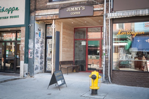
03142013-jimmyskensington590-11

I had a meeting today at Jimmy’s Coffee in Toronto’s Kensington Market, a newish coffee joint in the former Roach-A-Rama space.

While considering the selection of pastries, muffins and sandwiches on offer, I recognized a very distinct bold hand-lettered signage, that I knew I’d seen before. The signs looked exactly like the ones at Java Blend, my favourite coffee shop in North End Halifax.

ls

Seeing a similar kind of hand-writing wasn’t too surprising. For the last few years, tall, thin block lettering has been popular, and it was no surprise to see this style in a self-aware and hip coffee shop in Kensington Market.

But things got stranger when I looked up to order my coffee and made eye contact with the very same barrista I had gotten to know at Java Blend.

Java Blend

For a moment, space was bent.

Everything around me – the smells, the sites of the hand lettered sign, the friendly face across the counter – the warm lighting and amber colour scheme – the harsh churn of blending beans – served to collapse my sense of space bringing distant geographies face-to-face and space-to-space.

I snapped out of my space-bent daze and realized the recognition was mutual. We chatted.

Turns out Kate had moved from Halifax to Toronto a few years ago, and yes, she hand-lettered the signs.

It was a particularly strong case of geognitive dissonance.

Geognitive dissonance occurs when a combination of senses temporarily transports you to another specific space on the surface of the earth. It’s when notions of linear space collapse, and you can feel the connection between two places separated by vast distances.

It’s a phenomenon I’ve felt before, and every now and then it sneaks up on my, collapsing my notions of contiguous geography. It makes far-away places, past-homes, feel here and now and comfortably close.

WR_Map2

White Rabbit is a week long artist residency on the shores of the Bay of Fundy. Every year, 16 artists are invited to explore Red Clay, and engage in process-based art making in response to the landscape.

The residency culminates in a music and art festival, where visitors are invited to explore the land and enjoy the manifestations of the residency, including installations, workshops, performances and audio-tours. 

Every few years, the organizers of White Rabbit invite an artist to create a map to help festival goers find their way around the land to projects that are often deep in the Red Clay woods. Past map-makers have included Jayme Melrose, Sarah Burwash, and Chris Foster — artists and individuals who have been highly influential to my way of living and art practice. I was honoured to join the ranks of these esteemed creators, having been invited to be the resident Red Clay cartographer this past White Rabbit. It was a pleasure to see people navigate the festival with a map I had created!

whiterabbit

Festival goers figuring out where they are this year at White Rabbit


WR2014logofinal-608x608

Exciting news, readers!

This weekend, I am returning to Upper Economy, Nova Scotia, to participate in White Rabbit, an artist residency by the Bay of Fundy. The residency is hosted on a piece of land called Red Clay, a hilly terrain characterized by organic gardens, meadows, ponds and forests.

The week-long residency culminates in a festival, where visitors from near and far will come to enjoy the projects, celebrating with live music,  delicious food and fire spectacles.

The Bay of Fundy has the largest tides in the world, and I am excited to experience this epic, and subtly shifting landscape as we approach August’s full moon. I will be exploring, creating and learning with 15 other artists, including my brother Jonathan — a major support, influence and inspiration in my life.

Toronto Island Framed

Inspiration for the project, on Toronto Island this past winter.

My project, Framing Red Clay, proposes to place seven to ten frames of varying sizes around the land, with an illustrated companion map so visitors can find their way. The frames will be made of found material, incorporating the most natural and the most artificial objects littered throughout the landscape. It was inspiring by my wanderings around Toronto Island this past winter, where blank ferry schedule signs unintentionally left vistas framed for consideration.

Ideally, I hope to evoke laughter with this project. I also look forward to getting deep into ideas of the Nature-Culture binary that has characterized my Urban Geography practice. I am excited to collaborate with others, and am open to the inevitable changes to the project the intersection of the land, my state of mind, the weather and the dynamics of the group will bring to its manifestation.

Here’s to a week of contemplation, good food, friends new and old, and landscape-based art making. And see you next Saturday, at the White Rabbit Open Air Art Festival!

The following is a guest post by Urban Geographer brother, designer and artist Jonathan Rotsztain. He is the publisher of the West Dublin Monitor and is currently training in cartooning at the Center for Cartoon Studies in White River Junction, Vermont

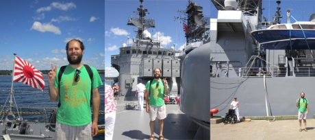
ships_start_jonathan

Jonathan aboard a visiting Japanese warship in the military
Halifax Harbour, 2011

harbour-600x398

Halifax/Dartmouth from above

Halifax, Nova Scotia was laid out in the interests of Empire. Following the successful English conquest of former French and Mi’kmaq lands—but before the expulsion of the Acadians—conquering army engineers superimposed a neat street grid over the lands west of the Halifax Harbour up until the Citadel defensive position. According to Halifax Street Names: An Illustrated Guide, “Town was laid out in squares or blocks of 230 by 120 feet, the streets being 60 feet wide; each block contained 16 town lots, 40 feet front and 60 feet deep, the whole divided into five divisions or wards.” How proper.

It may be apocryphal, but it’s said that the Halifax street grid was superimposed by surveyors looking at maps from London, England who never even set foot in the garrison during its 1749 founding and planning. The legend goes, that the powers-that-be didn’t anticipate the very steep hills up from the harbour and that during the cold Atlantic winters horses pulling heavy carriages were known to lose their foothold on the ice and go pummelling from the Citadel in the freezing water below. Whether this is true or not, having spent much time on the Halifax peninsula, it’s clear that its original architecture was indeed entirely military and that its civilian character has only evolved in that powerful echo.

Beyond its violent imperial roots, I spent much of the last four plus years living in Halifax marvelling at it’s apparent total lack of planning. Like much of North America, haphazard civic, industrial, business, retail and residential space butt-up and jut-out against each other. The impression I drew from navigating Halifax streets was one of short-term priorities triumphing over longterm planning, where consideration of how regular folks move and thrive in urban settings has been totally ignored.

This continues as the Halifax Regional Municipalities ignores its own design and regional plans and continues to encourage unbecoming sprawl. The result is areas like Hammonds Plains, where along its main artery, the Hammonds Plains Road exists as a kind of area I struggle to describe as sub-rural. On the outskirts of urban Halifax, it’s too agrestic too be properly suburban and yet it has many of the hallmarks of that kind of space. Residential sits atop business with many forests, fields and farms in-between. This is the outcome of a sparsely populated outpost growing for the sake of growth without thought to how different land uses interact with each other and the whole.

More recently, moving outside of Halifax and two hours down the South Shore another form of human geography struck me. Living in the LaHave area off Highway 331, I was faced with another kind of organic/haphazard human development. The 331 is given the tourist moniker “The Lighthouse Route” and it weaves its way close to the LaHave river in an organic rhythm that may date back to when the area was capital of French Acadia or even earlier to before European conquest.

The river road stands in contrast to the backroads. These I can best describe as spaghetti. They curve, narrow and bend in an even more organic fashion that was clearly the mother of necessity. As I travelled these often unpaved connectors I would wonder at how I could start in one area and end up in another. That these distant places across Lunenburg County were accessible to each other was one thing, but the journey along such unexpected paths add to their unreal feel.

south_shore_lahave01

 photo south_shore_lahave.gif

The drive from Bridgwater to Petite Riviere takes about half an hour but consists of 10 place names. This stretch of Highway 331 made up my immediate South Shore universe. Note: not all these photos of road signs are taken from the same direction.

When I first started visiting the Shore, trips contained to driving down the river road, I would laugh at the speedy and seemingly hilarious progression of multiple places names. One minute you’re in Pentz and the next LaHave, followed quickly by Dublin Shore and West Dublin. Yet once I relocated to the area and began to travel by the slower bicycle or on foot, I came to realize how reasonable these distinctions are. Indeed traversing the length of West Dublin by foot takes at least 25 minutes and it’s further still to come to the edge of Dublin Shore. In this case, my judgement was obscured by the mode of travel: the car. The original settlers were correct to consider their relatively small areas distinct because indeed they were isolated from each other, especially in the winter.

The South Shore too suffers wayward development, but like rural poverty it’s more hidden, except in the regional metropolis of Bridgewater where lack of planning is glaring on display. This is to say nothing of the relationships between the areas centres: the aforementioned Bridgewater, the town of Lunenburg, Mahone Bay and Chester (because I won’t be addressing them any further, but believe me there’s an interesting story there.)

My experiences in Nova Scotia—in Halifax and on the South Shore—has been one of grappling with the built environment and its organic and inorganic forms. In Halifax a garrison town has unintentionally grown into a minor regional metropolis while in the LaHave area the settlement has for the most part retained its original colonial feel. Both present distinct economic and infrastructural challenges and can be great cultural places to live. I’m glad to have taken this opportunity to share with you as I’ve sketched out some long brewing thoughts.

cloud map

It is common practice for people in the Netherlands to consult a cloud map – a map that shows the prediction for cloud coverage over the entire country for a 3 hour period.

Consulting the cloud map involves scrutinizing a simplified map of the Netherlands, as animated clouds swirl and cascade over the land and sea – typically in the northeasterly direction

This constant reference to the map of Netherlands contributes to the high degree of spatial literacy that exists in this country. People are aware of space here: how much space there is, the distance between things, and their relationships.

Spatial literacy translates to good urban planning practice, and probably stems from the relative lack of available land in the Netherlands. While in Canada Halifax continues to struggle establishing a green belt, in the Netherlands, the Ranstad has consciously conserved its “green heart” since the 1800s.

Spatial literacy manifests in the Netherlands in many other ways.

I feel it when I take the ferry to Amsterdam Noord, to my internship at the Pop Up City – from the waters of the IJ, I see the diverse elements that make up the urban environment, and their placement as stand alone objects, well places and related within a 3D plane.

I feel the spatial literacy when I can engage in a conversation about Amsterdam’s urban morphology with someone who has no relation to the field of urban planning or architecture.

I also feel it in the name of this country, and the language spoken here: ‘Nederland’ – a constant reference to geography, a rooted orientation in this world.

And I especially feel it when I look at the copious amount of maps and spatial analyses available from the municipal government.

And I feel it when people casually consult their cloud map, and absorb the entirety of the country in a single glance. A black dot with concentric rings marks where you are when you consult the map, and this simple graphic ties you, and space and everything together.

Spatial mind

________

On a slightly related note, If I were to design elements of a domestic train system, I would include a digital map in every train carriage that shows the progress of the route, and, when entering a destination station, would show a zoomed in map of the train entering the city.

This way, the rider could experience their journey outside of their direct experience of what is outside the window. Riders would feel greater connections to the places they are traveling through, and would feel more oriented and comfortable at their destination station.

Akimblog halifaxExciting news, readers!

A silkscreen print I made in the summer of 2011, as part of the North End Print Series is now featured as the banner for Akimblog Halifax’s Facebook pageAkimbo is Canada’s online source for visual art information, and has outposts in all major Canadian cities.

The print depicts four houses on Agricola Street just south of Willow Street, often referred to as the “4 sisters”. The houses are quaint, cozy and identical, but brightly painted in four different colours. They are a local landmark, and immediately recognizable.

Recently, the northernmost house (depicted as grey in the print) was painted purple, and renovated along with the other three houses. This is part of the recent intensification of gentrification in Halifax’s traditionally working class North End. The tenants of the 4 sisters were kicked out, and rents have been raised. This is part of a broader trend of pressure from capital causing the displacement of the neighbourhood’s residents, and the proliferation of “taste-culture” type businesses, that are not accessible to all residents.

As a white, young, creative-type from a relatively wealthy background, my presence in traditionally working class neighbourhoods with low rents means that it’s likely that I am an agent of gentrification. But these are the neighbourhoods I want to be living in – they are interesting, “authentic”, and village like. Can I do this without displacing the people that live in these interesting places?

As difficult as it may seem, I am not helpless in this fight. As much as you hear it around these days: gentrification is not natural, nor inevitable. As a potential agent of gentrification, it is your responsibility to be the ambassador of the current residents of the neighbourhood – the people who didn’t choose to live there, but can afford it and have built a nice life for themselves – and oppose any actions that will aid corporate condo-development. This means not accepting rent increases, and supporting tenants rights.

It is ambitious, but together, we can collectively put pressure against the pressure of capital and development. We can live side by side, and integrate without pushing out.

Initiatives like the “Shift Shop” highlighted on the Pop-Up City are good examples of proactive staving off of the forces of gentrification. The new young creatives in newly-gentrifying Noord Amsterdam have used their free time to create a pop-up style shop, not just for the new young creatives, but for the newly-immigrated and ethnically marked residents of the neighbourhood. BS? Maybe, I’ll let you know if I encounter it while I’m working in Noord, but in any case it’s a start…

Read the excellent zine “We Will not Go Quietly Into  the Night: Gentrification in Halifax’s North End” for more information about how to be a responsible non-agent of gentrification, specifically in the case of Halifax. 

Amsterdam Pocket Atlas

The City of Amsterdam has put together a very excellent Pocket Atlas, and I’ve had the good fortune of getting my hands on a copy.

The Amsterdam Pocket Atlas provides a thorough look into the spatial qualities of the city, illustrated by maps that describe such delights as Amsterdam’s historical morphology, its tram network, an overview of the city’s mix of functions, green spaces, housing prices and more – a wide range of clearly presented facts expressed in well designed maps.

How thoughtful of the City of Amsterdam to have the Urban Geographers of the world in mind when they put this excellent atlas together.

But I shouldn’t be so naive. It’s obvious from the tone and content of the Atlas that the City is appealing to the corporations and industries of globalized capital –  attempting to attract fickle, foot loose business by enticing them with the region’s diversity, accessibility & connectivity.

However biased the Amsterdam Pocket Atlas may be, it is nevertheless chalk-full of golden nuggets of geographic trivia – a treasure trove of urban geography delights.

The Atlas shed light on something I found particularly interesting: the limits that the Dutch are able to put on the boundaries of their cities. Under a different plan, Amsterdam could very well have expanded infinitely into its surrounding region. Harlem, Leiden, even sea-size Zandvoort could very well be a part of a North American style GAA (Greater Amsterdam Area).

Fixed Boundaries

Reading the excellent Amsterdam Pocket Atlas, I learnt that “for over a century the city acquire[d] space to expand by annexing neighbouring municipalities. Since 1966 the municipal boundaries have been fixed”.

What foresight, to limit the growth of a city – taming the beast before it wreaks havoc on the innocent villages of its hinterland.

Sprawling Toronto did not demonstrate this discipline when it became a mega-city in 1998. Instead, it has become a vast city-region, where a centralized, over burdened municipality has replaced effective local governance. It is a place where the forces of homogenization are something to constantly battle.

The behemoth Halifax Regional Municipality too, could have learnt a lesson from Amsterdam’s spatial discipline when it decided to amalgamate into a too-enormous-to-make-any sense city-region in 1996.

Amsterdam’s ability to limit its borders means a lot of things. It means it is excellently predisposed to make the necessary balance between an ever-densifying city and its highly fertile agricultural hinterland. While Halifax struggles to institute a greenbelt to control sprawl, Amsterdam is well poised for its future.

I don’t know why Dutch cities have tendencies toward spatial discipline, but it manifests in many different scales. For an example, I’ll focus on the neighbourhood level.

Spaarndammerbuurt

Spaarndammerbuurt makes itself explicitly known to its visitors

Neighbourhoods in Amsterdam are discrete spatial units. They are distinct, and have borders that can be easily referenced and mapped. Some neighbourhoods even have pseudo-gates, explicitly marking the space as part of the district: De Pijp’s In/Uit De Pijp sign and the same in Spaardammerbuurt.

In de Pijp

Uit de Pijp

It’s clear whether you’re In, or Uit of de Pijp, a neighbourhood in central Amsterdam

This is also not the case in Toronto – most neighbourhoods bleed into each other, and people have a hard time of agreeing on what’s what.

Its seems the Dutch have no need for the advice dished out in Kevin Lynch’s tome The Image of the City. There is a strong tradition of spatial discipline here. Exploring the city, I feel firmly rooted in where I am, and entirely oriented. Dutch cities are bastions of imageability.

When I’m living in Halifax, I’ll often walk up and down Fuller Terrace. It’s a beautiful street in the city’s North End – one of my favourites –  and many friends live along its wood-sided, leafy sidewalks.

A house I pass on these walks features a nice landscape architecture feature. It’s something I’ve noticed in other places since, and one I’d like to share with you.

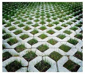
Grass grid

A concrete grid, that allows grass to grow through it.

Regular readers will get why I like this approach to designing surfaces: it is a thought provoking union between artificial concrete and natural grass — though of course, concrete is as natural as grass is human-influenced.

The concrete-grass grid reminds me of some thoughts I had while exploring Tempelhof park in Berlin.

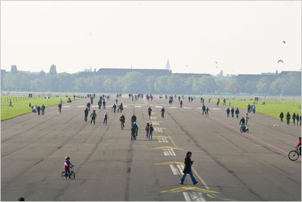
tempelhof 1Formerly an airport, now a park.

Formerly a Nazi-era airport, Tempelhof has since been transformed into a gigantic park in the middle of the city. The defunct-runway provides an immense open space with site lines that run undisrupted along the city’s horizon. It provides quite a contrast to Berlin’s otherwise densely populated landscapes.

Templhof

Templehof

Now that Tempelhof airport is a park, some of its features have transformed to reflect that.

Beyond the obvious appearance of park goers and picnic benches, I noticed a more subtle transformation: the runway’s asphalt is slowly yielding to wild plants. When it functioned as an airport, the tarmac would have been tirelessly kept weed free. Now, the asphalt is slowly incorporating itself into a non-monocultural system. Grass is spreading over concrete, much like the above mentioned concrete-grass grid – which I think is quite a nice landscape architecture feature.

Halifax

I am pleased to present to you a sampling of clips/animated GIFs from my presentation Everything is Everything (Urban Political Ecology: Politicizing Urban Natures). The animation is based on a body of academic literature and my thesis work at McGill University. It is a playful visualization that is multi-disciplinary, informed by history, philosophy, geography, ecology and geology.

I am continuing to develop the presentation, and am currently expanding it by animating poignant examples of urban-nature from my native Toronto. The examples there are abundant, and the results will be inevitably whimsical.

I will keep you updated with my process, but for now enjoy clips from Everything is Everything as presented at the 2011 Fuller Terrace Lecture Series‘ evening of talks themed “The Nature of Things

Enjoy:::::

Though trees and modernist buildings seem diametrically opposed, they are both the result of the processing of material from the earth. Both their designs are repetitive, and logically follow from basic units:

Tree-Building

Our cities are built on top of and out of the earth. The quintessential wood paneled houses of Halifax are made from the trees that used to cover the Peninsula. The glass and steel that compose the city’s skyscrapers, though from farther away, are too the result of natural processes:

Halifax

As human populations (i.e. western imperial societies) grew and spread over the surface of the planet, so did their systems of reason and rationality. At first, Nature was conceived as terrifying, something to be revered and despised. But as untouched Nature began to become scarce, receding in the face of increased population and technology, it became something to be desired, enjoyed, conserved. Nature is a fluid concept:

Nature

The world is complex, and it’s often hard to draw a line between where the natural ends and the artificial begins:

Complex

Like the bees, we gain our energy from fruits and vegetables, which stem from flowers. The bees use their energy to build their hives, and we, our cities:

Same-Same

I am excited to announce that I have applied to be a presenter at OCAD’s upcoming Urban Ecologies conference in Toronto this June.

My proposal is to do a presentation similar to the lecture I gave during Halifax’s Fuller Terrace Lecture Series’ 2011 season. There, for an evening of talks under the theme “The Nature of Things”, I spoke about the history of the concept of nature, and society’s entrenched nature-culture binary which works to obscure the questions that matter most in contemporary environmentalism: who are the winners and losers of humans’ inevitable impact on the planet.

Tree-Building

Clip from “Everything is Everything” – an animation/presentation about nature and cities.

For the lecture, I created a whimsical animation as an easily accessible version of the concepts of Urban Political Ecology – the body of literature that informed my undergraduate thesis, which in turn inspired the lecture. I used examples from Halifax to illustrate these concepts and relate them to the audience’s day-to-day experience of the city. Indeed, cities are places where the supposedly natural and non-natural come together most poignantly.

Halifax

Halifax, as animated for the presentation.

I present to you my proposal for the upcoming Urban Ecologies conference at OCAD. The base of the presentation will remain similar to that which was presented in Halifax – but the examples will be customized to my native Toronto, where instances of nature-culture are abundant: the Don Valley Brick Works, the system of ravines that run through the city, the “re-naturalization” of the Don River, and the Leslie Street spit.

Enjoy – and whether I am accepted or not, see you at the Urban Ecologies conference in June!

Daniel Rotsztain Presentation Written Abstract Proposal Daniel Rotsztain Visual

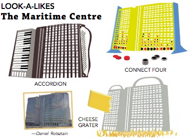
LOOKALIKES, a feature I sometimes illustrate in the Dalhousie Gazette’s fantastic Other Gazette has continued into 2013.

Check out these most recent submissions: fanciful transformations of Halifax landmarks and quintessential urban-infrastructure into an unlimited number of lookalikes!

Lookalikes - Macdonald Bridge Tower

Lookalikes Aliant building

Lookalikes Ferry