Archives for posts with tag: halifax

03142013-jimmyskensington590-11

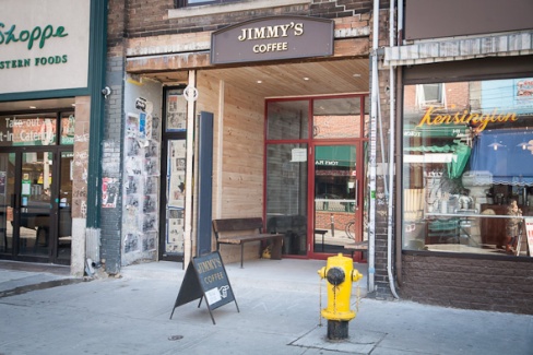
I had a meeting today at Jimmy’s Coffee in Toronto’s Kensington Market, a newish coffee joint in the former Roach-A-Rama space.

While considering the selection of pastries, muffins and sandwiches on offer, I recognized a very distinct bold hand-lettered signage, that I knew I’d seen before. The signs looked exactly like the ones at Java Blend, my favourite coffee shop in North End Halifax.

ls

Seeing a similar kind of hand-writing wasn’t too surprising. For the last few years, tall, thin block lettering has been popular, and it was no surprise to see this style in a self-aware and hip coffee shop in Kensington Market.

But things got stranger when I looked up to order my coffee and made eye contact with the very same barrista I had gotten to know at Java Blend.

Java Blend

For a moment, space was bent.

Everything around me – the smells, the sites of the hand lettered sign, the friendly face across the counter – the warm lighting and amber colour scheme – the harsh churn of blending beans – served to collapse my sense of space bringing distant geographies face-to-face and space-to-space.

I snapped out of my space-bent daze and realized the recognition was mutual. We chatted.

Turns out Kate had moved from Halifax to Toronto a few years ago, and yes, she hand-lettered the signs.

It was a particularly strong case of geognitive dissonance.

Geognitive dissonance occurs when a combination of senses temporarily transports you to another specific space on the surface of the earth. It’s when notions of linear space collapse, and you can feel the connection between two places separated by vast distances.

It’s a phenomenon I’ve felt before, and every now and then it sneaks up on my, collapsing my notions of contiguous geography. It makes far-away places, past-homes, feel here and now and comfortably close.

free store amsterdam

I’ve noticed the existence of many  ‘wegeefwinkellen‘ in Amsterdam – free stores!

A free store is a simple space, attended by an individual or group, where a wide variety of stuff — clothing, dishes, books, toys, outerwear — is available to take, for free. You can also drop off your unneeded things at a free store, but you don’t have to. There is no exchange necessary at the free store. In this way, free stores are effective mechanisms for the redistribution of the abundance of stuff in the world.

I love the concept of the free store. It has the same principles as the Really Really Free Markets in Halifax, Toronto, and I’m sure many other cities around the world, that I wrote about last summer. I noted in that post that, to make a real impact on the way we engage with our cities — the city as a social gathering place and not  solely a market place — a city needs permanent infrastructure to host free markets.

Well readers, Amsterdam’s wegeefwinkellen are just that. Permanent free stores – solid, reliable places for the free exchange and redistribution of the abundance of things in the world.

Most of the free stores I’ve experienced in Amsterdam have been related to some sort of broader social project. Most commonly, they are in squats, or former squats. There’s one at the bottom of my staircase in the former-squat I’m currently staying at.

My favourite free store however, hands down, is a little wood structure at the gate of the Buurt Boerderij – the Neighbourhood Farm in Westerpark, in Amsterdam’s west. The Buurt-Boerderij is a lovely urban farm, surrounded by industrial, residential, rural, green and commercial cityscapes. Its medium size fields are planted in rows and   grazed by goats. There is a cafe and bar in the farm house, with a large patio that stretches toward the fields and onto the land, where small groupings of tables and chairs invite endless hangs.

7355559420_942fee81cd_z

Hangs, at the Buurt Boerderij

015-04_gevels

The Buurt-Boerderij, from what I can piece together, is run in conjunction with a therepeutic mental-health centre. The residents of the centre, which sits beside the farm house, tend to the farm’s gardens, animals, and kitchen. They also attend and organize the free store: a lovely little, well-maintained place, that always offers something, if you need it.

cloud map

It is common practice for people in the Netherlands to consult a cloud map – a map that shows the prediction for cloud coverage over the entire country for a 3 hour period.

Consulting the cloud map involves scrutinizing a simplified map of the Netherlands, as animated clouds swirl and cascade over the land and sea – typically in the northeasterly direction

This constant reference to the map of Netherlands contributes to the high degree of spatial literacy that exists in this country. People are aware of space here: how much space there is, the distance between things, and their relationships.

Spatial literacy translates to good urban planning practice, and probably stems from the relative lack of available land in the Netherlands. While in Canada Halifax continues to struggle establishing a green belt, in the Netherlands, the Ranstad has consciously conserved its “green heart” since the 1800s.

Spatial literacy manifests in the Netherlands in many other ways.

I feel it when I take the ferry to Amsterdam Noord, to my internship at the Pop Up City – from the waters of the IJ, I see the diverse elements that make up the urban environment, and their placement as stand alone objects, well places and related within a 3D plane.

I feel the spatial literacy when I can engage in a conversation about Amsterdam’s urban morphology with someone who has no relation to the field of urban planning or architecture.

I also feel it in the name of this country, and the language spoken here: ‘Nederland’ – a constant reference to geography, a rooted orientation in this world.

And I especially feel it when I look at the copious amount of maps and spatial analyses available from the municipal government.

And I feel it when people casually consult their cloud map, and absorb the entirety of the country in a single glance. A black dot with concentric rings marks where you are when you consult the map, and this simple graphic ties you, and space and everything together.

Spatial mind

________

On a slightly related note, If I were to design elements of a domestic train system, I would include a digital map in every train carriage that shows the progress of the route, and, when entering a destination station, would show a zoomed in map of the train entering the city.

This way, the rider could experience their journey outside of their direct experience of what is outside the window. Riders would feel greater connections to the places they are traveling through, and would feel more oriented and comfortable at their destination station.

Akimblog halifaxExciting news, readers!

A silkscreen print I made in the summer of 2011, as part of the North End Print Series is now featured as the banner for Akimblog Halifax’s Facebook pageAkimbo is Canada’s online source for visual art information, and has outposts in all major Canadian cities.

The print depicts four houses on Agricola Street just south of Willow Street, often referred to as the “4 sisters”. The houses are quaint, cozy and identical, but brightly painted in four different colours. They are a local landmark, and immediately recognizable.

Recently, the northernmost house (depicted as grey in the print) was painted purple, and renovated along with the other three houses. This is part of the recent intensification of gentrification in Halifax’s traditionally working class North End. The tenants of the 4 sisters were kicked out, and rents have been raised. This is part of a broader trend of pressure from capital causing the displacement of the neighbourhood’s residents, and the proliferation of “taste-culture” type businesses, that are not accessible to all residents.

As a white, young, creative-type from a relatively wealthy background, my presence in traditionally working class neighbourhoods with low rents means that it’s likely that I am an agent of gentrification. But these are the neighbourhoods I want to be living in – they are interesting, “authentic”, and village like. Can I do this without displacing the people that live in these interesting places?

As difficult as it may seem, I am not helpless in this fight. As much as you hear it around these days: gentrification is not natural, nor inevitable. As a potential agent of gentrification, it is your responsibility to be the ambassador of the current residents of the neighbourhood – the people who didn’t choose to live there, but can afford it and have built a nice life for themselves – and oppose any actions that will aid corporate condo-development. This means not accepting rent increases, and supporting tenants rights.

It is ambitious, but together, we can collectively put pressure against the pressure of capital and development. We can live side by side, and integrate without pushing out.

Initiatives like the “Shift Shop” highlighted on the Pop-Up City are good examples of proactive staving off of the forces of gentrification. The new young creatives in newly-gentrifying Noord Amsterdam have used their free time to create a pop-up style shop, not just for the new young creatives, but for the newly-immigrated and ethnically marked residents of the neighbourhood. BS? Maybe, I’ll let you know if I encounter it while I’m working in Noord, but in any case it’s a start…

Read the excellent zine “We Will not Go Quietly Into  the Night: Gentrification in Halifax’s North End” for more information about how to be a responsible non-agent of gentrification, specifically in the case of Halifax. 

Amsterdam Pocket Atlas

The City of Amsterdam has put together a very excellent Pocket Atlas, and I’ve had the good fortune of getting my hands on a copy.

The Amsterdam Pocket Atlas provides a thorough look into the spatial qualities of the city, illustrated by maps that describe such delights as Amsterdam’s historical morphology, its tram network, an overview of the city’s mix of functions, green spaces, housing prices and more – a wide range of clearly presented facts expressed in well designed maps.

How thoughtful of the City of Amsterdam to have the Urban Geographers of the world in mind when they put this excellent atlas together.

But I shouldn’t be so naive. It’s obvious from the tone and content of the Atlas that the City is appealing to the corporations and industries of globalized capital –  attempting to attract fickle, foot loose business by enticing them with the region’s diversity, accessibility & connectivity.

However biased the Amsterdam Pocket Atlas may be, it is nevertheless chalk-full of golden nuggets of geographic trivia – a treasure trove of urban geography delights.

The Atlas shed light on something I found particularly interesting: the limits that the Dutch are able to put on the boundaries of their cities. Under a different plan, Amsterdam could very well have expanded infinitely into its surrounding region. Harlem, Leiden, even sea-size Zandvoort could very well be a part of a North American style GAA (Greater Amsterdam Area).

Fixed Boundaries

Reading the excellent Amsterdam Pocket Atlas, I learnt that “for over a century the city acquire[d] space to expand by annexing neighbouring municipalities. Since 1966 the municipal boundaries have been fixed”.

What foresight, to limit the growth of a city – taming the beast before it wreaks havoc on the innocent villages of its hinterland.

Sprawling Toronto did not demonstrate this discipline when it became a mega-city in 1998. Instead, it has become a vast city-region, where a centralized, over burdened municipality has replaced effective local governance. It is a place where the forces of homogenization are something to constantly battle.

The behemoth Halifax Regional Municipality too, could have learnt a lesson from Amsterdam’s spatial discipline when it decided to amalgamate into a too-enormous-to-make-any sense city-region in 1996.

Amsterdam’s ability to limit its borders means a lot of things. It means it is excellently predisposed to make the necessary balance between an ever-densifying city and its highly fertile agricultural hinterland. While Halifax struggles to institute a greenbelt to control sprawl, Amsterdam is well poised for its future.

I don’t know why Dutch cities have tendencies toward spatial discipline, but it manifests in many different scales. For an example, I’ll focus on the neighbourhood level.

Spaarndammerbuurt

Spaarndammerbuurt makes itself explicitly known to its visitors

Neighbourhoods in Amsterdam are discrete spatial units. They are distinct, and have borders that can be easily referenced and mapped. Some neighbourhoods even have pseudo-gates, explicitly marking the space as part of the district: De Pijp’s In/Uit De Pijp sign and the same in Spaardammerbuurt.

In de Pijp

Uit de Pijp

It’s clear whether you’re In, or Uit of de Pijp, a neighbourhood in central Amsterdam

This is also not the case in Toronto – most neighbourhoods bleed into each other, and people have a hard time of agreeing on what’s what.

Its seems the Dutch have no need for the advice dished out in Kevin Lynch’s tome The Image of the City. There is a strong tradition of spatial discipline here. Exploring the city, I feel firmly rooted in where I am, and entirely oriented. Dutch cities are bastions of imageability.

When I’m living in Halifax, I’ll often walk up and down Fuller Terrace. It’s a beautiful street in the city’s North End – one of my favourites –  and many friends live along its wood-sided, leafy sidewalks.

A house I pass on these walks features a nice landscape architecture feature. It’s something I’ve noticed in other places since, and one I’d like to share with you.

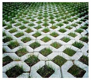
Grass grid

A concrete grid, that allows grass to grow through it.

Regular readers will get why I like this approach to designing surfaces: it is a thought provoking union between artificial concrete and natural grass — though of course, concrete is as natural as grass is human-influenced.

The concrete-grass grid reminds me of some thoughts I had while exploring Tempelhof park in Berlin.

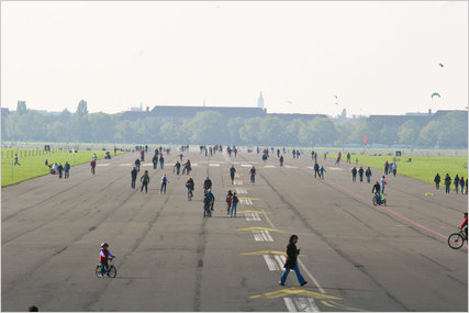
tempelhof 1Formerly an airport, now a park.

Formerly a Nazi-era airport, Tempelhof has since been transformed into a gigantic park in the middle of the city. The defunct-runway provides an immense open space with site lines that run undisrupted along the city’s horizon. It provides quite a contrast to Berlin’s otherwise densely populated landscapes.

Templhof

Templehof

Now that Tempelhof airport is a park, some of its features have transformed to reflect that.

Beyond the obvious appearance of park goers and picnic benches, I noticed a more subtle transformation: the runway’s asphalt is slowly yielding to wild plants. When it functioned as an airport, the tarmac would have been tirelessly kept weed free. Now, the asphalt is slowly incorporating itself into a non-monocultural system. Grass is spreading over concrete, much like the above mentioned concrete-grass grid – which I think is quite a nice landscape architecture feature.

Halifax

I am pleased to present to you a sampling of clips/animated GIFs from my presentation Everything is Everything (Urban Political Ecology: Politicizing Urban Natures). The animation is based on a body of academic literature and my thesis work at McGill University. It is a playful visualization that is multi-disciplinary, informed by history, philosophy, geography, ecology and geology.

I am continuing to develop the presentation, and am currently expanding it by animating poignant examples of urban-nature from my native Toronto. The examples there are abundant, and the results will be inevitably whimsical.

I will keep you updated with my process, but for now enjoy clips from Everything is Everything as presented at the 2011 Fuller Terrace Lecture Series‘ evening of talks themed “The Nature of Things

Enjoy:::::

Though trees and modernist buildings seem diametrically opposed, they are both the result of the processing of material from the earth. Both their designs are repetitive, and logically follow from basic units:

Tree-Building

Our cities are built on top of and out of the earth. The quintessential wood paneled houses of Halifax are made from the trees that used to cover the Peninsula. The glass and steel that compose the city’s skyscrapers, though from farther away, are too the result of natural processes:

Halifax

As human populations (i.e. western imperial societies) grew and spread over the surface of the planet, so did their systems of reason and rationality. At first, Nature was conceived as terrifying, something to be revered and despised. But as untouched Nature began to become scarce, receding in the face of increased population and technology, it became something to be desired, enjoyed, conserved. Nature is a fluid concept:

Nature

The world is complex, and it’s often hard to draw a line between where the natural ends and the artificial begins:

Complex

Like the bees, we gain our energy from fruits and vegetables, which stem from flowers. The bees use their energy to build their hives, and we, our cities:

Same-Same

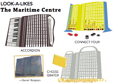
LOOKALIKES, a feature I sometimes illustrate in the Dalhousie Gazette’s fantastic Other Gazette has continued into 2013.

Check out these most recent submissions: fanciful transformations of Halifax landmarks and quintessential urban-infrastructure into an unlimited number of lookalikes!

Lookalikes - Macdonald Bridge Tower

Lookalikes Aliant building

Lookalikes Ferry

the archives

As part of my professional life as an Urban Geographer, I recently finished up some work as a research assistant for Concordia Geography Professor Ted Rutland.

My research brought me to Halifax Regional Municipality’s Archives, which are located on the edge of Dartmouth in Burnside Industrial park.

Burnside is an awful place – a car-oriented mess of highways and warehouses. It is not a “place” in the traditional sense – only in that it occupies specific space on the surface of the earth.

The placelessness of Burnside is especially punctuated by the fact that no one is ever doing research on Burnside itself; almost everyone using the archives is interested in finding out about a very small portion of the HRM: peninsular Halifax, the traditional core of the region.

Eavesdropping on daily inquiries to the archivist, I would consistently over-hear people interested in Halifax-based avenues of research: the city’s former street car network, the Morse Tea building on Hollis Street, properties on Spring Garden Road. Even the internet password is “barrington”, downtown Halifax’s main shopping street.

It’s interesting that the HRM archives are located so far from the place that people are actually interested in researching. I suppose that the needs of the archives for immense warehouse space (data takes up a lot of room) logically pushed it into the lower-cost suburbs. It is a shame, however, that the brain of the city is located so far out, in the Burnside industrial mess – a place that, beyond the 52 Crosstown bus, can only be accessed by those with a car.

Halifax-01

This is Halifax, today. The main geographical feature of Halifax is that it is a peninsula. Peninsular Halifax protrudes out from the Bedford Basin into the greater harbour. To the west, a thin strip of water known as the North West Arm separates it from Spryfield and the Purcell’s Cove Road area – the “mainland”.

There are no connections over the North West Arm between peninsular Halifax and the mainland – one must travel to where the land connects – at the Rotary – to get anywhere along the western shores of the Arm – a relatively far distance to travel to somewhere that is not too far away, as the crow flies, or the car drives.

Halifax cognitive-01

The consequences of this on the city’s collective cognitive geography is enormous. With no connections, the mainland seems incredibly far away, more like the map pictured above. The mainland is also fairly undeveloped — it remains largely forested, and, along Purcell’s Cove road you can access William’s Lake, and Tea Lake, some of Halifax-area’s most beloved swimming spots.

Halifax with Harbour Drive-01

In the 1960s, an ambitious highway plan would have seen the extension of a highway-like Barrington Street through the downtown, around Point Pleasant Park, and over to the mainland, as roughly pictured in the map above.

The plan, known as Harbour Drive, was never realized, and the highway-zation of Barrington stopped at the Cogswell Interchange.

I often think that the consequences of a built Harbour Drive on our relationship with Halifax would have been profound. Instead of thinking about Halifax-proper as an isolated peninsula, it would form a larger whole, and my life would probably be more integrated into the paths and projects associated with the Spryfield and Purcell’s Cove area.

But while thinking this, I also correct myself because if Harbour Drive was built, it would have been a gross super-highway, leading to the development of Fairview-  & Dartmouth-style suburbs that I would never have any reason to go to – there would undoubtedly be a deficiency of a public realm and walkable, public space.

Since Harbour Drive was never built,  beautiful forests remain.

Halifax with pedestrian bridges-01

It is pity, though, that the mainland seems so far from my life, when it’s actually so close.

It would be so lovely, if pedestrian bridges stretched, across the North West Arm, as pictured above, connecting Halifax and the Mainland –  between the end of South Street and Dingle Park, Point Pleasant Park and Purcell’s Cove. It would bring the forest, the lakes, and the fine air of the mainland closer to our lives, in a lovely, healthy way.

Sept 19 Mayoral Debate poster

I designed a series of posters for Our HRM Alliance’s three councillor candidate debates during the 2012 HRM municipal election. The posters are meant to evoke the reality that each district is an essential part of the greater whole.

Spryfield

You may notice that the districts appear rather large: there are only 16 of them, down from formerly 23. The Nova Scotia Utility Review Board (the seemingly true decision makers in this town) decided last year that 23 districts was too many, and to be more efficient, the number would be widdled down to 16. Less people to argue, right?

South end

Also see the September 19 Mayoral debate poster.

As part of the Dalhousie Gazette‘s fantastic Other Gazette, my brother and I have been taking a variety of Halifax landmarks and transforming them into things they kind of look like.

The feature inevitably grew out of one of our favourite teen pass-times, “Everything is Everything”, a drawing game that involves turning a circle with four spokes into anything your opponent challenges. “Everything is Everything” was also the title of the Fuller Lecture I gave in the summer of 2011.

Look-a-likes may be an exercise in exaggerations – but in a world where the fractal nature of the universe is relatively common knowledge, is it so farfetched to suggest the Halifax peninsula looks like a silly mermaid?