Archives for category: malmo

Every day this month, I’ve biked from central Malmö to Alnarp, as small rural community just outside the city and the home of SLU, the university I’m currently doing an exchange at.

The bike ride takes about 45 minutes, and in this short distance, I pass through many distinct landscapes: neighbourhoods within Malmö itself, a highway interchange zone, industrial Ärlov, a bird reserve, and rural fields, all before getting to Alnarp.

Despite being within biking distance, because of all these landscape changes, Alnarp feels very, very far away from Malmö. And phenomenologically, it is. As I’ve explored before in past posts, distance matters less than feeling in determining how “far away” a place is.

Like the short ferry ride between downtown Toronto and Toronto Island, whenever a change in material reality is experienced, places seem very far away, no matter how far the distance.

And on my bike ride from Malmö to Alnarp, I experience many changes in material reality.

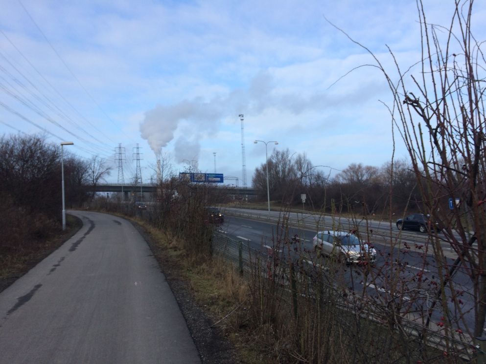
The city drops out, and then I peddle through the land of highway interchanges. The bike path weaves up, down and through bridges and overpasses, floats over the expressway and in between unkempt shrubs. At night, hundred of rabbits scurry between the vegetation, lending this landscape an even more ethereal quality.
IMG_9054.JPG

The land of highway interchanges

Then, there is the land of the sea – the bike path borders a bird reserve, and the horizon extends infinitely. The smell oscillates from the salty murkiness of the coastline to an almost candy-like scent from the nearby garbage processing plant. The matted grasslands and water channels, the hawks, ducks, geese and crows flying around – this is a wholly distinct material reality where my thoughts expand as my breath shortens to keep up with small inclines.

img_9058

The land of the sea

Finally there is the land of the fields.  Naked patches of deep black soil envelop the bike path, and linear bands of trees, bent in the wind add directionality to this change in material reality.

img_9063

The land of the fields

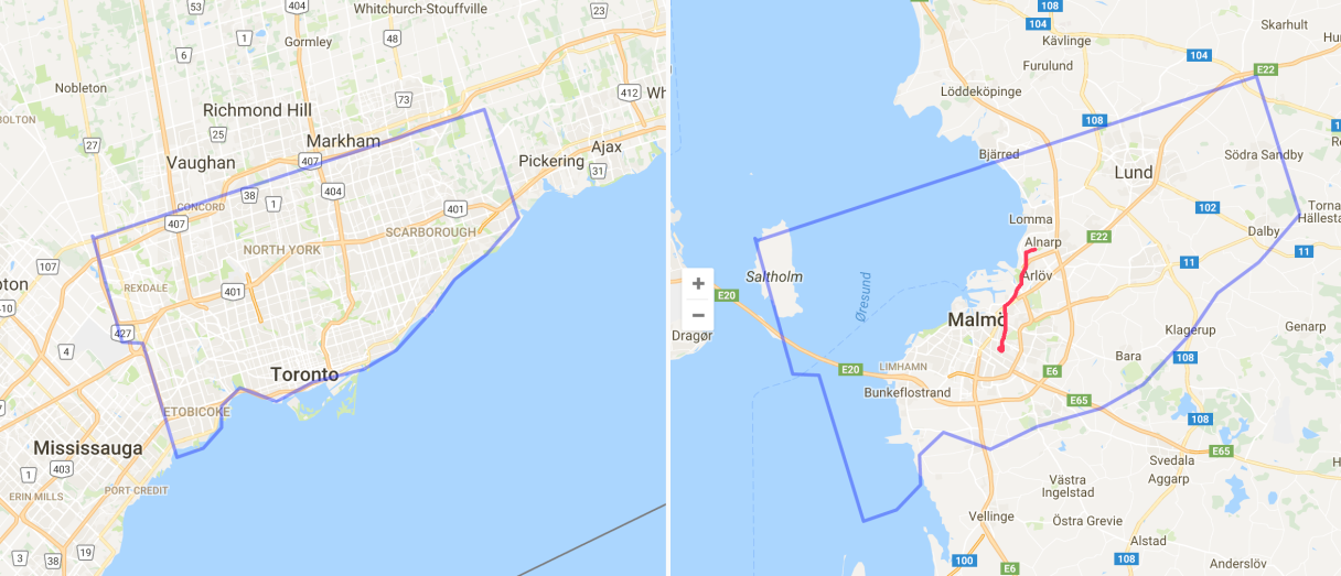
I arrive at Alnarp tired, dazed and feeling distant. Despite this being the distance of roughly the distance of Toronto’s Ferry Terminal to Davenport Rd  and Dufferin (still very much in the city, and a commute I made often last I lived in Toronto), the many changes of material reality make Alnarp very much a distinct place, and my life in Southern Sweden is characterized by inhabiting many places at once, despite occupying the footprint of a tiny portion of the City of Toronto.
Screen Shot 2017-01-27 at 8.26.03 PM copy2.png

Map comparing distances in Toronto and Malmö – the red line represents my bike ride, and the short distance that takes me through so many changes in material reality. 

malmo

I’m from Toronto – Grid City. I like a good orthogonal city plan. A city where North is up, South is down, and East and West, are, you guessed it, side to side.

Well, Toronto is not exactly a perfect grid. As Dylan Reid has explored on Spacing, Toronto is in fact a series of micro grids, stitched together, with some exceptions for topography that even the imperially-decreed gridded city plan couldn’t ignore. But that’s a fine detail, a technicality. The macro grid – the one that made up of Toronto’s major streets –  is based on a series of 2km-spaced concession lines, and it defines how the city is organized.

Growing up in Toronto, City of Grids, I think, is part of why I have such a keen sense of direction. People in Toronto, they use cardinal directions to direct people where they need to go. “Go north on Bathurst, then west on Eglinton” they’ll say, and it makes perfect sense. As a result, I have North permanently etched into my mind as essential to understand where I am.

Even when a city’s grid doesn’t match the cardinal directions, a perfect grid means that people use cardinal directions anyway. In Montreal, what people call North is in fact more North-West. In Guelph too. Rather than constantly say “go north-west, then south-west”, people have collectively adjusted the meaning of north in the local context.

Other cities – where the grids aren’t so reliable – aren’t like this. In Halifax, an otherwise perfect grid bends around the Citadel and Common. The grid dissolves into spaghetti as the straight elements (the roads), navigate rounded elements (the Common). As a result, people are more inclined to say “Go up Robie”, “Go down Agricola”, instead of cardinal orientation, and it just makes more sense.

halifax

In Newfoundland, at least, according to my friends, directions are much more story-based than cardinal- based.  St. John’s is pretty loopy city, and the small downtown grid quickly dissolves to negotiate the city’s various hills and steep slopes. Here, instead of “Going north on Prescott Street”, directions are more based on stories, and landmarks. “Go past Rosie’s Convenience, and make a left”.

st-johns

As you may know, I am currently living in Malmö, Sweden, and will be exploring the Skåne region for the next five months.

Malmö is especially disorienting to me because, as this post’s title suggests, the city is almost a grid, but, it’s not quite a grid. Two streets that I think are parallel end up veering away from each other, and intersecting at other points, as the map below highlights.

malmo2

I’ve explored how different cities present different flavours of disorientation, and as kinds of disorientation go, this might be the toughest challenge so far. I’m so sure I know where I am, using my Toronto infused griddy-knowledge, only to be constantly lost, and going in the wrong direction. In almost making sense as a grid, but then not being a grid at all,  it has been a humbling, getting lost experience (and this is a good thing).

This posts title was inspired by The Almost Nearly Perfect Peoplea less than perfect exploration of Scandinavian culture by Michael Booth.