

The Law Library at McGill University in Montreal, commissioned for Mr. Edward Brook by his mother for Christmas.
The Law Library at McGill University in Montreal, commissioned for Mr. Edward Brook by his mother for Christmas.
This post first appeared on Spacing Toronto, and was originally titled #FrenchTO

Last week I was driving along College enjoying a jazzy groove on 90.3 FM Espace Musique. When the song ended and the hosts returned to their banter, I found it strange to hear familiar Toronto neighbourhoods, streets, and venues spoken about in French.
This experience is definitely not restricted to the airwaves. I regularly overhear groups of people speaking French on the street or subway, talking about Toronto. It’s about the hundredth time hear College Street pronounced as “Rue de Collège” that I recognize Toronto as a thoroughly French city.
When you look into Toronto’s history, it makes sense that people would speak of Rue de Collège today. In fact, Toronto’s history is steeped in French. As plaques along the Humber River will remind you, the first Europeans here were French, and the maps they left of the GTA show familiar places covered in French names.
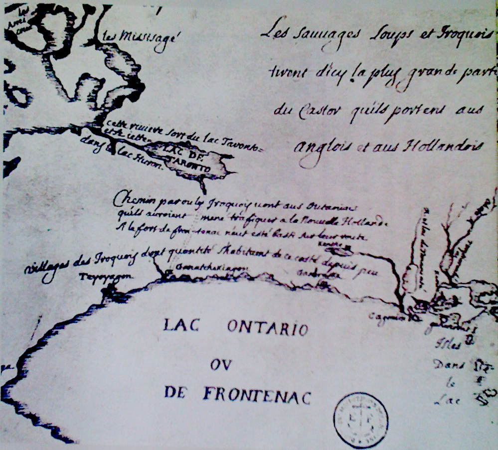
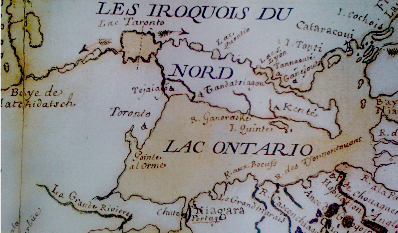
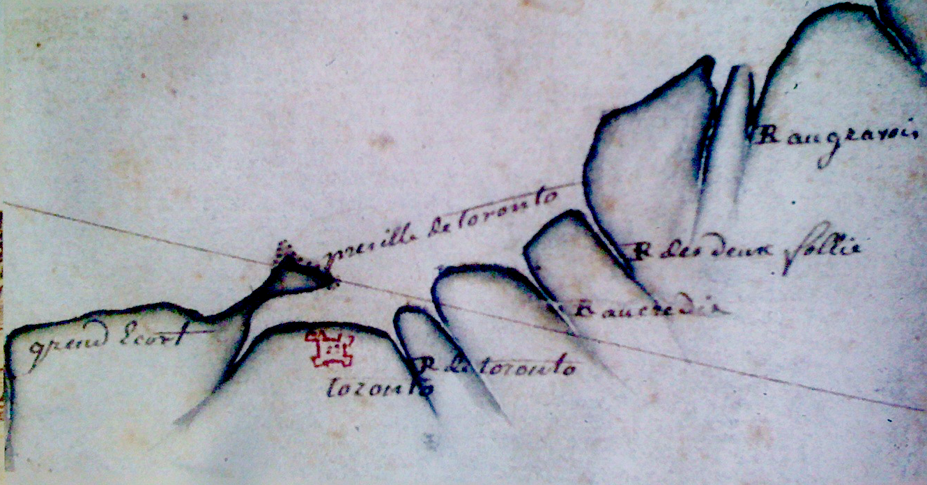
The above maps are from the Historical Atlas of Toronto, by Derek Hayes, a necessary book for the Toronto-curious
Thinking about these old French maps of Toronto, it becomes less surprising to hear about Rue de Collège, or people calling Toronto’s Subway system the Métro, the way they refer to the systems in Paris and Montreal. I actually prefer the French term. Calling it a subway is misleading, as much of the tracks are actually above-ground. You need look no further than LRTs and streetcars to realize that confusing terminology can derail a reasonable conversation about rapid transit.
Recognizing all this Torontonian French history and hearing French heard on the streets and Metro makes me appreciate the significant French contingent in this city. Though Toronto is still reeling from its solid British colonial roots,the latest census lists 1.1.% of the city with French as their mother tongue (compared to 3% Italian, and 2% Portuguese). With roughly 50,000 French speakers in total, an informal survey on Toronto’s streets reveals that all dialects of French spoken worldwide — Quebecois, European French, Francontarian, Acadian, Manitoba-French, African French, Caribbean French, Middle Eastern French — are spoken in Toronto. Where else, other than maybe Paris, Marseille or Montreal, could you find this many ways of speaking la belle langue?
Though the dialects of French in Toronto come from far and wide, they do coalesce in a few places. There’s the Alliance Française, an organization that promotes the use of French language and culture, and Labo, a French arts organization. Toronto’s weekly L’Express newspaper, “le journal français du Grand Toronto” is a venue for the city’s Francophones of all origins.
In the pages of L’Express, Toronto is often called La Ville Reine — the Queen City. Though generally defunct, the nickname keeps our city bonded to its colonial British and puritan roots, and in a tongue and cheek way reminds us of historical rivalries between Toronto and Quebec, back when Montreal was sparkling city number one, and down the 401, Toronto the Good was simmering on dull.
Maybe it’s these past rivalries, and their continued manifestations today, that keep Toronto from fully embracing its French soul.

For one thing, our streets aren’t lined with Deppaneurs (Quebec’s version of the convenience store), where you can buy your groceries, cleaning products, wine and beer all in the same place. For now, Toronto only has oneDeppanuer — on Rue de Collège. While not quite the same (it’s a restaurant), this Deppaneur certainly carries the spirit of Quebec into Toronto.
The pilot program to put LCBO kiosks in 10 grocery stores is a good start, but here’s hoping that Toronto will take the cues from its thoroughly French past and present, and at some point, let its convenience stores sell beer.
This post originally appeared on Spacing Toronto

Last November, my father and I to took the bus to the airport.
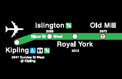
At the regular TTC fare of $3 a ride, taking the Bloor-Danforth line to Kipling then catching the 192 Rocket (an express bus that travels along highway 427) is a bargain compared to the alternative $50-ish cab ride. Taking the subway and the bus, my dad and I were surprised that we could get from our house to Pearson in under an hour.
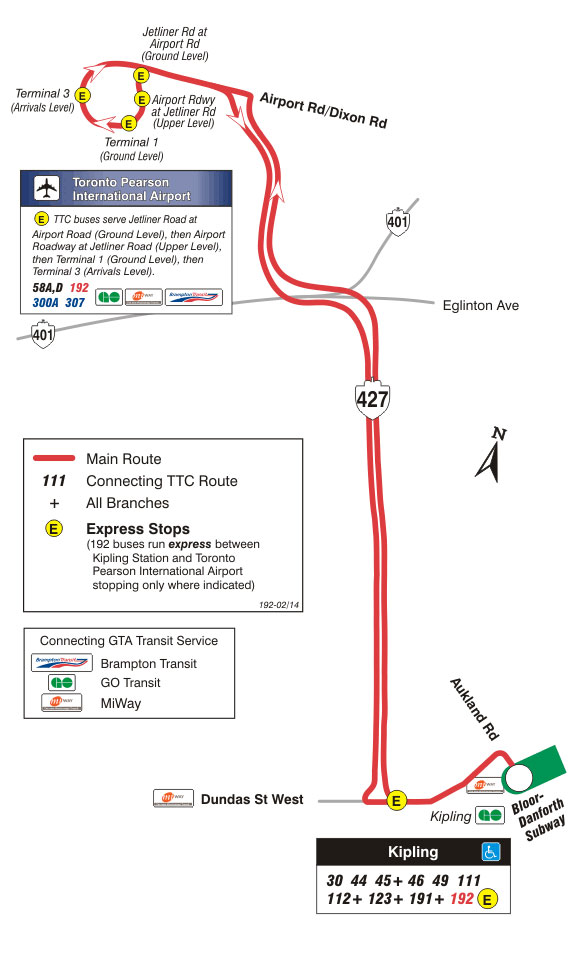
The 192 Rocket travels from Kipling Station to Pearson Airport along the 427. Image courtesy of the TTC.
It makes me wonder. Why isn’t the 192 Rocket promoted by the TTC, with maybe a little airplane icon above Kipling station on the subway map? Other then seeing people with luggage in tow every now and then on the Bloor-Danforth line, and the odd Air Canada flight attendant in full uniform, you’d never realize that the TTC was connected to the airport.
In Montreal, the bus to the airport was introduced in 2010 with a major ad campaign. The bus — numbered 747 — is painted brightly with the image of an airplane. As the bus makes its way through downtown Montreal and onto the highway toward Trudeau International, it becomes a moving billboard advertising itself as a viable transit option to the airport.
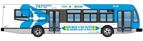
The 747 bus in Montreal. Image courtesy of STM.
I am definitely excited about the opening of the Union-Pearson express train in 2015. This city will benefit greatly from a direct route between its airport and central transit hub. At roughly $20-$30 per ride however, the UP Express won’t exactly be accessible to every Torontonian. I do hope the UP Express doesn’t mean the end of taking the bus to the airport.
And why is the TTC bus to the airport so secret anyways? It definitely affirms my suspicions that Toronto is thoroughly an Insider’s city. We Torontonians like our secrets. Our gems are accessible, but you’ve got to find them yourself. We have a great ravine system, but its trails remains largely unmarked. And just try to make your way through the PATH system for the first time.
So, apologies for breaking Torontonian code by exposing the express airport bus to the internet masses. But hey, it’s a good service!
Daniel Rotsztain is the Urban Geographer. Check out his website or say hello on Twitter!
Leading image by James Bow, from Transit Toronto
In honour of winter, I would like to re-post an essay I wrote in 2009 for Spacing Montreal while I was going to McGill University for Urban Geography. It was a very snowy winter that year. Kind of like this one, in Toronto.
Are there any natural paths along your walks this winter?
____

When walking through Montreal, we cannot deny the usefulness of the shortcut. Shortcuts that are used a lot demonstrate the lovely chaos that occurs when a side walk doesn’t quite meet our pedestrian needs.
Most pedestrians share one goal: to get between two points in the city as fast as possible. Ideally, urban planners would design paths that meet our needs perfectly, with major routes that bring the maximum number of people to the places they want to go.
Well, the utopian city in a planner’s mind does not exist. We all have different orientations toward the city. We all have different ideas what we need to do and where to go, with different preferences for transportation. Ideally, a city is flexible enough to accommodate that.
Though planners couldn’t possibly provide sidewalks wherever you would want to walk, the city makes itself available for some crafty self landscape design. A simple example is the phenomenon of natural paths.
The most common example of natural paths are the ones that form at many street corners. Cutting every corner makes a walk much faster. So, inevitably, corner sidewalks are often usurped by a pythagorean line from A to B.
Living in a winter-city gives Montrealers a unique perspective on the natural path phenomenon. Every winter in Park Jeanne-Mance, the city ploughs paths that trace the perimeter of the park, the slowest route for someone who wants to walk across.
Having to walk through the park daily, I’ve found that shortcuts through the snow appear every winter in the same place. A path that initially manifests as a narrow track of boot prints, meandering past trees and picnic tables, slowly evolves to become wide and navigable.

We can read these indexes of movement as evidence of Montreal’s collective unconscious. The natural path through the snow also shows me that ultimately, I rely on the actions of others in urban space. It’s angle shortens the walk for the most number of people, and is a beautiful instance where natural human behaviour manifests in collective rationality and the logic of a city can be easily read.
Another example can be found on Ave des Pins, just west of du Parc. When the city redesigned the intersection to fit a more human scale, a large fence was built separating the north and south sides of Pins in order to prevent pedestrians from jay-walking through the fast-moving traffic. Despite these efforts, a path has formed directly through the seemingly indestructible steel fence. We can again appreciate the organic and collective nature of our negotiation of Montreal’s urban space and realize that ultimately, our city is formed by its citizens: our actions, our behaviours and our habits.


Click map to enlarge


The above was presented at the exciting Urban Ecologies conference 2013, which wrapped up today. If you have any questions about Carolinia, please contact me.

I love the existence of “now leaving” signs in between the towns and cities of Europe. Much like their “now entering” counterparts, a “now leaving” sign is simply the name of the town but with a red cross through it.
These signs will often be on two sides of the same post, marking the literal in-between space in the middle of one municipality and the other. For cartophiles, this is an exciting place to be — a place where you can really “feel the map”.
I have noticed a lack of “now leaving” signs in North America. I find that this marks a sort of geographic dishonesty, as if the town, or city or province is too proud to admit that it has met its end. The example I think about most often is at the border of Ontario and Quebec along highway 401. When you’re driving east toward Quebec, you have no idea when Ontario will end — it’s only the <<Bienvenue au Quebec>> that finally gives it away, and in this way, I feel Ontario resisting the reality of its finiteness.
UPDATE: After speaking with my good pal, the Peripatetic Philosopher, I feel a little differently about the above-described “dishonesty” of the lack of ‘Now leaving’ signs in North America.
Here’s what he had to say about the subject:
“I think the root reason why we don’t have these signs in Canada is because we are less concerned with the identity and boundaries of our towns. This used to be a huuuge concern for Europeans since they have had countless disputes over territory.
“As much as I’d love to see these signs in Canada, it’s also nice to think that our boundaries don’t really exist. Driving to Montreal, I always look out the window and wonder ‘Is this Quebec? Did we pass the sign. This looks like Quebec’…then I realize I’m still in Ontario. Here, the real demarcation between places is by visual differences in the landscape. and our places are more about landscape than towns. For example, I don’t care about Gwimbelberry or Tinkertown or Haliburton, I care about the Canadian Shield and I don’t need a human-made sign to tell me when I’ve arrived.”
Negotiating a new place comes with inevitable comparisons to places you are familiar with. This is an inescapable quality of being human: we integrate new knowledge by embedding it within the systems of knowledge we’ve already constructed. When you visit a new city, it really is difficult to accept it as a place in-and-of itself, and comparisons to London, New York, Toronto, Venice are almost inescapable…
Along these lines, I’ve detected a specific comparison mechanism I’ve employed in my negotiations of Amsterdam: comparing the scale of the built environment. This allows for comparison of two cities not by specific architectural styles, but the size of the elements of the cityscape. My analysis of scale falls along an axis with “cozy, human scale” on one end and “car-oriented hell” on the other, with lots of variation in between.
Here are two fun “scalar equivalencies”, or “synonymous scales” that I’ve encountered and thought-up while exploring Amsterdam. I am sharing them because they stood out as quite stark to me, and allowed me to meaningfully understand these parts of Amsterdam without a constraining comparison. Comparing places by scale allows the places to “be themselves”, while allowing a meaningful understanding of the potential uses of these spaces outside my direct experience of them.
Amsterdam’s IJburg <————> Montreal’s Plateau


Amsterdam’s newest neighbourghood, IJburg, is built in the scale of early 20th century North American urbanism, much like Montreal’s central Plateau neighbourhood. Cozy and compact, walkable and diverse, this landscape is not hostile to car use or ownership. There is density, but there is also space.
Noord Amsterdam <————> Portland, Oregon


Portland is interesting because it is defined by a sort of “walkable suburbanism“. The streetscapes are dominated by cars, parking lots and strip malls, but wide sidewalks, bike lanes, and lots of interesting businesses and organizations make for an easily navigable city by foot or bike. Amsterdam Noord has a similar feel: in amongst the huge roads, parking lots and car repair shops are nice, human scale restaurants and shops, bike lanes and generally well-scaled streets for non-car exploration.
I had a neat experience of geognitive dissonance the weekend before last, when I visited by former city-of-residence Montreal, along with many many other people from Halifax.
On Sunday afternoon, I was delighted to find that the visionary producers of Pop Montreal, and local Mile-End public space advocates and super group RuePublique, planned the final day of the fantastic music and arts festival to coincide with Les Bons Voisins de St Viateur, the annual St Viateur Street fair. Providing all-afternoon free shows on the street, Pop Montreal also had its Puces Pop event in the basement of a church directly fronting the fair. The result was a constant flow of people throughout the day, enjoying the street-hangs, slowly filtering through the church doors to enjoy the dense display of crafts on offer.
Having thoroughly enjoyed the Black Street block party only one week earlier in Halifax, I was psyched to get a dose of some Montreal same-same but different. Though entirely different from the residential, leafy neighbourhood times of the Black Street block party, Mile End’s St. Viateur festival was Montreal’s gritty urban iteration of the same culture of the do it yourself, for yourself spirit, and take-back-the-streets attitude.
Several blocks were closed to cars, and the commercial high street yielded to small-job booths of crafters, free bike repair, and food stands by and for neighbours. Both Black and St Viateur festivals rejected corporate aesthetics, favouring the small scale and the scrappy. A successful intervention on the street was the laying of sod — inviting passersby to lie down in the middle of the street, reclining in repose, fulfilling the essence of the Montreal hang in an atypical mid-street locale. A characteristically grey but sunny autumnal day enveloped the hangs, and highlighted the beauty of St Viateur’s built form.

Scrappy DIY art-projects on St Viateur (courtesy of RuePublique Facebook group)
Midday I found myself on a picnic table in front of a brick building at the St Viateur street fest’s mid-point. I was in good company, joined by a few friends I’ve met in Halifax, laughing and reminiscing about nights’ passed. Contently, I looked around to marvel at the delightful street scene, quickly realizing that about 40 people surrounding me were from Halifax, or connected to the city in some way. I tuned into the sound beginning to pour from the nearby bandstand, and started to bopping my head to familiar tunes from Halifax’s Old and Weird. The picnic table, the closed off street, the brick buildings framing the scene, the people surrounding me, and the music narrating it all — the scene was an exact reproduction of SappyFest, an indie rock festival in Sackville New Brunswick, that similarly attracts droves from Halifax, only in this instance, it was several months later and several hundred kilometres further west.
Compare this Montreal Mile End street scene…


…to a similar scene in Sackville, New Brunswick
A head-ache, it was – a veritable space-warp. Here was a social network I directly associate with a specific place – Halifax (and including Sackville, the Martime region, I guess) – transposed onto another city, a city that I associate with an entirely different social network to boot.
Pure geognitive dissonance.


One of the things I miss most about Montreal is its parks.
Montrealers, with their unmistakable joy-of-life, live their lives publicly, in the city’s streets and laneways, and in its parks.
When I lived in Montreal, my local park was Jeanne-Mance: a beautiful green field stretching three long blocks, bordered by tall maples and elms, and framed by the mountain on its western edge. Parc Jeanne Mance offers a lot — wide parades, playgrounds, sports fields of every sort, perimeter paths for jogging and walking — but my favourite element of the park, hands down, is at its south-east end.
Here, at the corner of Duluth and Esplanade, is the loveliest of shady tree-groves. A desire line meanders in between woody perennials that provide equal parts back-rests and shady canopies. Here, under the immense and leafy growth, you can recline, quietly watch-people and be people-watched, and run into friends who are using the park as a shortcut from the Plateau to downtown. Stop and chats are as abundant as the old urban growth; picnics, instruments, naps and solo reading sessions common.
This is where I spent most of my time in summer-Montreal, where I began to sink my teeth into the magical intimacy a city can provide to someone open to it. Parc Jeanne Mance and its other-neighbourhood counterparts are the true gathering spaces of Montreal.
Halifax, my current city-of-residence on the other hand, has no such park — and as a result, no such park culture.
As a resident of the city’s North End, my park options are limited, and baby I can feel that park deficiency.
That’s why I was delighted to attend this past weekend’s CKDU picnic, an outdoor bbq at the Commons hosted by Halifax’s campus radio station. It was an opportunity to enjoy the park in a way I hadn’t before — in a way that was distinctly more Montreal.
See, the Commons sort of sucks, in my opinion.
There is undeniable value in the refreshment it provides for the city. A great greenspace, no matter how it’s designed, provides invaluable pleasures and alleviences to the experience of urban living: we are all richer for breathing deeply and having access to spaces such as these.
But the landscape architecture of the Common hardly fosters the sort of gathering and straight-chills that Montreal equivalents harbour.
Halifax’s Common is barren. Save for the perimeter, which is indeed lined with beautiful old trees, there really is no nice place to sit. There actually is one, right in the middle of the North Common, however, nine times out of ten, it’s occupied by the punk-dog kids, and other parties — which is great, they’re great — but the space is so small, that trying to share it would those who are already there is sometimes uncomfortable.
Most of the Commons’ space is instead occupied by sports fields. It’s true, that on a sunny day the park’s baseball diamonds, soccer fields, and cricket pitches are completely full, a testament to the real demand for sport-space in the city. But it doesn’t make for good gathering, and in my opinion, is a real loss for the city, and a damn shame.
The fact that a giant pile of soil supporting a fresh layer of grass and vegetation recently freed from behind a chain link fence is now consistently used as a place for people to gather and sit is evidence of the need for Chills-space in the Common.
At the CKDU picnic, a temporary landscape architecture of tents, tables, vintage clothing stores, and music equipment transformed typically ephemeral “passing through” space at the edge of a soccer field, and marked it instead as a gathering space where people could comfortably hang in the presence of others and the lovely shade provided by a loose collections of tented canopies. The simple intervention in space introduced by the picnic transformed the park dramatically for the better.
I spent a whole bunch of hours at the CKDU picnic, soaking up the temporary Montreal-style park hang. I relished this Commons-hang, and ever-so-thoroughly enjoyed the chance encounters with passing friends who were using the Commons as a short cut between downtown and the North End. It made me sad to think how fleeting this use of the Common was going to be — gave me a glimpse of the sort of park the Commons could be with better design.
How easy it would be to plant a grove of trees in this small disused sliver of the Commons — what a lovely legacy that would be to the park-hangs of Halifax’s future.
Leading image by Chris Foster

I’ve written a lot recently about the concept of geognitive dissonance: geography-induced cognitive dissonance. These are moments when the supposed linearity of space gets warped, and you experience a non-contiguous geography. Times when your senses mix, and vision defers to more subtle, powerful experiences of taste, touch, smell that break at the seams of our notion of objective space. Basically, geognitive dissonance is when you’re in one place, but something causes you to feel like you’re in another place, a place you’ve been before and know quite well.
I realize that I’ve inadvertently written about geognitive dissonance many times without naming it as such.
I’ve written about how the sweet-stale subway scent in Berlin transported me to Toronto’s TTC;
I wrote about closing my eyes on Toronto BIXIs, and feeling as if I were on a bike I got to know in Montreal;
I explored the proliferation of heterogenous big box architecture, and how it served to emphasize the difference of context in a pharmacy of the exact same layout in Montreal versus Halifax.
Though there isn’t a post about it, today with my dad, I biked a former rail path that has since been converted into a bike trail in Nova Scotia, and when I closed my eyes, felt I was in Toronto’s belt line – the same soft gravel crunching under moving wheels, the same sense of enclosure between the trees on each bank, the same light filtering through the leaves.
This is a powerful concept, I think.
It demonstrates that reality is not linear. That our world can never be known fully as objective, and that our senses have transformative, transport-ative properties. Vision and observation only go so far to explain the relationships in this world, as I, for one, experience geognitive dissonance quite often. Perhaps daily.
I know reality through a nuanced, deeply entrenched personal geography, and that personal geography is located squarely in the realm of my senses, altering my perceptions and the spatial locations of vantage points that I interpet the world from.
// a study of typologies

