Archives for category: guelph

Alice Street map

There are, perhaps, no streets more different in Guelph than Alice Street and Woodlawn Road.

On Alice, a jumble of brick houses have been built up to the edge of the street. Before the rise of big box, Alice Street was a hybrid residential-commercial thoroughfare and the heart of the Italian community with general stores and shoe shops in its reconfigured houses. Many of these shops have since turned back into houses, but have been forever distinguished by their past modifications. The effect is an incredibly unique streetscape, like I’ve never seen before, a street of houses with unique DIY renovations, where neighbours hang out on front porches, cars drive slow – the feeling of village and the height of urbanity.

Those aforementioned big box stores – well, they eventually ended up on Woodlawn Road, a street at the northern edge of the city and home to Guelph’s Wal-Mart, Home Depot and various other gigantic corporate retailers.

Woodlawn is a street no one loves but everyone must visit eventually. When I first moved to Guelph, I ended up there countless times, dreading my visits but in need of inexpensive home items only sold there. Woodlawn is the typical non-place at the edge of every city in North America – characterized by the bright signs of fast food restaurants and the complete rejection of walking as a mode of transportation. There are no public gathering spaces on Woodlawn.

It’s easy to love Alice Street. It’s not so easy to love Woodlawn.

So I mapped both, trying to extend my love of place in general to a place that’s hard to love.

And of course, Woodlawn isn’t a non-place, it’s a real place. By choosing to create an illustrated map of it, I’m trying to find its essence beneath the concrete and beyond the international corporate crust that has founds its way there. By mapping Woodlawn, I discovered unique businesses, residential hold-outs, beautiful groves of trees and desire lines criss-crossing its railways.

The map of Woodlawn is an invitation to explore the Woodlawn Road of your city.  Once you get out of your car and walk, it’s easy to find magic beyond the highways.

Woodlawn_Finish2.png


Cities of.png

As my last post explored, Southern Ontario’s physical geography is often ignored, and its landscape is often derided as being flat, monotonous and boring.

Disconnected to the subtle features of the landscape by 400-series superhighways, big box plazas and its relentless grid, its understandable that the infinite beauty of the land beneath the concrete would be, for the most part, forgotten.

Beyond the highways, Southern Ontario’s rich glacial soil has been sculpted into dramatic river valleys, cuestas, waterfalls and the rolling hills of drumlin fields by millennia of water movement.

My map (leading image) is an effort to re-assert the geologic features most prominent in these three very connected cities at the western end of Lake Ontario. Happy exploring!

City of Drumlins

Southern Ontario’s physical geography is often ignored – its landscape is often derided as being flat, monotonous and boring.

But don’t let the gigantic highways and big box plazas fool you – this isn’t so! Southern Ontario’s rich glacial soil has been sculpted into dramatic river valleys, cuestas, and rolling hills by millennia of water movement.

In Guelph, the city is characterized by hills – drumlins, shaped by the glaciers. Many of these drumlins, due to their prominence, have been topped by important buildings and landmarks – like the Church of Our Lady, and Johnston Hall at the University of Guelph.

But many have been neglected by Ontario’s relentless grid, with roads cutting straight up the steep side of a hill, unwavering from the grid’s linearity. In recent years, the places of prominence at the tops of these hills have become just another patch of endless development.

In an effort to re-assert Guelph’s hills/drumlins into the consciousness of its residents, I enlisted the trusty power of an illustrated map to emphasize the prominence of the city’s hills in it’s urban landscape (leading image).

Because I’m new’ish to Guelph, I spoke with many longtime Guelphites to make sure every hill was included and properly named — like neighbourhoods, the names of Guelph’s hills are often contested, but after asking many people, I chose the most common names to include on the map.

The map was first released at 2016’s Kazoo! Fest Print Expo – while several Guelphites knew about the city’s hills, many did not know they were drumlins, while many others had never thought of the city’s topography and appreciated the geographic insight.

As your Urban Geographer, I’m motivated to bring the unique and magical elements of the land beneath the concrete into focus. Stay tuned for more maps!


Guelph_Transit_237Guelph is a small city with a small bus system.

Unlike in larger cities where many buses ply the same routes all day with 5-10 minute headways, Guelph can’t afford to do that – there are too few people.

What I initially felt was a bummer — buses every 20-30 minutes at peak times and every hour at other times of day — turned one of the system’s greatest strengths: reliability.

This seems like a major paradox – how can you build a robust transit system by providing less?

Transit planners have a maxim that people won’t adopt public transportation unless its frequent and reliable. In Toronto, it often feels like it’s frequent but not reliable. In Guelph, however, the service may not be frequent, but it is very reliable.

Because the bus comes so infrequently, users are forced to use the schedule to see when their bus is coming. The bus system becomes more like a train system in this way – fixed times when the bus will be coming that you can plan your routine around.

While the buses sometimes detract from their schedule, key points in their routes, like the University Centre and Guelph Central Station, put them back on schedule. At these transfer points, the bus will wait until their scheduled departure time to depart.

I think Guelph’s bus system would be much more frustrating if it didn’t follow a schedule and used the same amount of service at more random intervals. The degree of reliability would tire out the most dedicated transit user.

But as it stands, it works great. As Guelph grows, it will require a larger fleet of buses with more frequency – but until then, and in other small cities in Ontario and beyond, the reliability of a less is more approach to transit, while at first seeming like a contradictory approach to establishing a robust transit system, is a good way to go.

IMG_8354.JPG

As you may know, I recently moved to Guelph, and am spending lots of time getting to know another corner of the Southern Ontario industrial lands.

Guelph is made up of many neighbourhoods that each have their own distinct feel. (Dare I say, Guelph is a City of Neighbourhoods?)

I live in The Ward.

The Ward was first developed to house factory workers and is characterized by humble brick houses scattered between factories.

Some of these factories are still active, like Owens Cornings Reinforcements on York Road, which putters and sputters all day manufacturing something I still don’t quite understand. Other factories have been long decommissioned, and remain semi-abandonded, with only a barbed wire fence signalling anyone still cares about them. Others have been demolished, leaving behind huge brownfields that have yet to be remediated, subdivided and developed.

Compared to Guelph’s wealthier neighbourhoods, The Ward has always been a bit neglected — but this is a good thing. Without much attention paid to it, its obvious from its ramshackle built form that The Ward was left unzoned for the better part of its existence. This left a lot of space for its historically Italian residents to expand their homes willy-nilly to accommodate their needs – whether that was to add extra bedrooms to their upper floors, or an entire front edition that would house a store front.

IMG_8336.JPG

The result is an incredibly eclectic neighbourhood, where every house is completely different from the next, each DIY renovation facilitating a need, each random addition representing a very specific human desire.

In The Chronology of City Repair, Mark Lakeman talks about how we are all villagers, and modern city development with its homogenous, top down plans and developments prevent us from expressing ourselves in the places we live, taking away our “villager” status.

IMG_8350.JPG

Its evident from its ad hoc shacks, its piece-meal additions and its random store front editions, that the villager spirit is very much alive in The Ward.

At least it was alive, at a certain time. With many of the commercial additions now inactive, and many unimaginative new homes, it’s hard to say if the villager spirit still remains as strong as the marks it left in its historic architecture.

Like many neighbourhoods similar to it in cities across the world, The Ward is changing. Its Italian residents are aging, their families living in other, shinier parts of town. Young families are moving in, and housing prices are rising.

Will the new residents of the Ward continue inhabiting this place in an ad-hoc basis, and be able to express their specific needs in the architecture? Do the by-laws, the DNA of the city, allow for a continuation of The Ward’s independent spirit?

Even if the by-laws changed, I believe that the places we live strongly effect who we are. And if there’s anything we can learn from the ramshackle, ad hoc architecture of The Ward, it’s that we can make our architecture work for us.

IMG_6977

Downtown Guelph has many coffee shops – more than its population would seem to be able to support.

Cafes on offer include local mega-chain Planet Bean, hyperlocal one-of-a-kind Red Brick, and the more of a restaurant Cornerstone.

There’s also the Common.

The Common is a small Toronto chain that has been slowly expanding from the original Dufferin Grove location to Bloor Street in Bloordale and the Annex. Their recent, and most ambitious, expansion to Guelph might be due to the large concentrations of ex- and sometimes-Torontonians in the city, looking for a piece of home while away.

The Common in Guelph is a carbon copy of its Toronto counterparts: whitewashed walls, blond wood, minimal furnishings yet eclectic and warm, a simple menu of espresso-based coffees and few baked goods.

The other day, I went to the Common in Guelph to study. I overheard a group of people talking about Toronto intersections, “Spadina and Dundas”, “Gerard and University”. I looked over to the next table and saw someone reading the latest edition of NOW magazine.

IMG_6974

“Where am I?” I thought.

I looked out the window, and despite what I saw, heard, and felt, there was Guelph – its hills, its limestone buildings, its city hall.

IMG_6975

The Common in Guelph – a major case of Geognitive Dissosance.

401 north

All my life in Toronto, the 401 has been north of where I’ve lived.

But now, in Guelph, the 401 is south of where I live.

Yet the 401 has endured as north in my mind. I often find myself looking at maps of Guelph, completely disoriented as to where I am, all because I’ve flipped the map in my mind so that 401 is squarely north, where it’s always been.

I am so surprised that this highway — which I often perceive as the bane of my existence — would play such a prominent role in my understanding of geography.

But it undeniably is.

It’s going to take a long time for me to adjust to the 401 being south. Maybe I never will. The 16 lane wide concrete and metal belt stretching laterally across Southern Ontario and through Toronto will prove hard to shift in my mental landscape.

As I continue to negotiate my identity – Am I from Guelph? Am I from Toronto? Am I spending too much time in Toronto when I should be embracing Guelph? – I’ll take thinking of the 401 as south as a sign that my internal geography has shifted.

tumblr_nemp8gMwUe1t0nycgo3_500

How does that old adage go? Ontario is flat- as flat at can be. 

For those who have explored the province, however, you know this is simply not true.

Look at Toronto on a map and all you see is a seemingly limitless grid of streets, extending indefinitely for kilometres in every direction (except to the south – the sea’s there!). But explore a little, and you’ll soon find steep ravines and the dramatic topography of river valleys spread all throughout the city, hidden beneath the grid.

A Harbourfront photography exhibit debunked the concept of a featureless Toronto topography last summer with No Flat City – a series of photos that explored Toronto’s more steep side.

But even for those in the know, that old notion that Ontario is flat is hard to shake.

Visiting Guelph in the past, the city seemed like another instance of even-grounded Ontario – but for a few rolling hills it felt like a limitless plane on which agricultural, suburban and urban development could be built indefinitely.

But as I get to know Guelph – drive down its streets, bike up its hills and walk along its rivers and alleys – I am learning the subtle topography of this place. As I push into Guelph’s topography, those subtle inclines become more dramatic – I understand where the highest bluffs and lowest river valleys are – I know where to go for the best views. (So far, that’s on College street just west of the University of Guelph, where the city looks like it’s emerging from an lush forest).

Whenever I look at a physical topographical map, I’m always surprised to see how unvaried the landscape seems from a large scale. I run my hands across the raised surfaces — even mountains appear like small bumps rising only slightly from the landscape.

There’s a subjective experience of topography that makes the hills appear beneath your fingers. Every huff of breath, every extra push in the pedal, every time your ears pop in the car, you are pushing into topography and making the ups and downs of landscape real and legible.

Guelph

Exciting news, readers!

Your Urban Geographer is expanding his experience of Southern Ontario and setting up shop in Guelph.

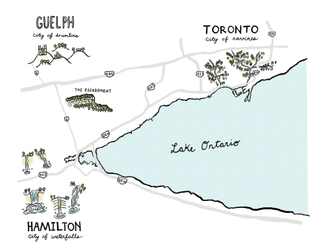
Guelph is a lovely little city just down the road from Toronto (the road happens to be the 401…), and is the perfect environment to pursue a Masters in Landscape Architecture from the University of Guelph. That’s right, friends – this urban geographer is no longer just a passionate observer of the city – he’s going to be making city too!

I’ve had the pleasure of getting to know this city slowly from afar, visiting for music festivals or to just spend time with friends. From afar, I’ve developed a few ideas and speculations about Guelph that I’d like to note before getting into the nitty gritty of its culture, ecology, history, geology etc.

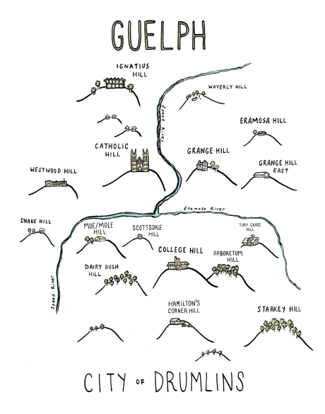
Guelph has strong connections to its agricultural hinterland. Since its inception, the city has identified as an agricultural centre, and the University of Guelph started as the University of Toronto’s agricultural college, splintering as an independent institution only 50 years ago.

You can take a city bus to the countryside in Guelph. You can bike to farms in under 10 minutes. Guelph has resisted the sprawl typical of Southern Ontario cities, and has only recently given in to density, with its residential suburbs in its south end. Even though it was designated by the Ontario government as a growth centre which lead to the south end’s suburbs, the sprawl is twice as dense as typical Ontario developments. The city also fought passionately against a Wal-Mart opening up – which it inevitably did, but the battle is evident of a populace who understands the limits of growth, the need for density and the value of preserving a distinction between town and country.

Guelph’s nickname is the Royal City – but I think it should be the Rural City – a city that has, not always perfectly – found the balance between urban and rural – two human settlement patterns that depend on each other anyway.

Guelph is a 10 minute drive north of the 401, and I think this separation has been critical to its positive development — not awash with a sea of cars coming through the 401, the “inconvenience” of the 8 km between Guelph and the highway has made all the difference.

Guelph is vital – its a small Ontario city where people are interested in each other. Its ecology is alive – built at the confluence of the Eromosa and Speed Rivers – tributaries of the Grand River which run into Lake Eerie. The rivers move fast and the air is clean and refreshed by its moving waters.

My favourite view of Guelph so far is from the high lands south of the Eramosa River, looking north toward the city centre. It is a verdant, lush city, humid in the late summer heat. But instead of the ubiquitous glass condo tower, the only thing that rises from the green is the Basilica of Our Lady of the Immaculate – a grand cathedral that centres Guelph as would a church in a small city in France or Germany.

I’m interested in my relationship to Toronto as I study in Guelph. I will go back often – as your Toronto-based Urban Geographer I naturally have lots to do there with forthcoming projects and articles.

I am excited to avoid driving to Toronto as much as possible. I have romantic notions of taking the train — a GO line runs to Guelph, but for now its a commuter train that only leaves twice in the morning, coming back twice in the evening. It stops just short of Guelph in in Aberfoyle at the other times of the day due to conflicts with the CN/CP schedule, the industrial owner of the stretch of track. This short-stopped service is holding Guelph back from the urban energy of Toronto and the southern Ontario mega region. Maybe this is a good thing.

If not the train, the GO bus does excellent service between downtown Guelph and Union Station in Toronto, or between the University of Guelph and York University. With the pending York subway extension, this might be a pretty good option!

I am excited to feel Toronto as an insider/outsider – to understand the city in a regional context. To feel the dynamism of its urban energy as something I’m not used to. I wonder what details I’ll pick up – what difference I will notice. How it will feel to enter the city from the west.

I look forward to updating you on my insights of Southern Ontario and its many cities. I hope you enjoy this slightly new perspective as your Urban Geographer.